IMAGES TAKEN NEAR TO
Dumbuie Avenue, DUMBARTON, G82 2JP
Introduction
This page details the photographs taken nearby to Dumbuie Avenue, G82 2JP by members of the Geograph project.
The Geograph project started in 2005 with the aim of publishing, organising and preserving representative images for every square kilometre of Great Britain, Ireland and the Isle of Man.

There are currently over 7.5m images from over14,400 individuals and you can help contribute to the project by visiting https://www.geograph.org.uk
Image Map
Images are licensed for reuse under creativecommons.org/licenses/by-sa/2.0
Notes
- Clicking on the map will re-center to the selected point.
- The higher the marker number, the further away the image location is from the centre of the postcode.
Image Listing (53 Images Found)
Images are licensed for reuse under creativecommons.org/licenses/by-sa/2.0
Image
Details
Distance
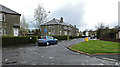
1
Gruggies Burn
For more information about the burn, see Image
In the present photograph, the backs of houses on Dunbritton Road can be seen on the right; to the left, are those of Strowan's Road. In the distance, near the left-hand edge of the picture, is the dark double-peaked shape of Dumbarton Rock (Image and Image).
See also Image; it was taken from the same point, but is a view in the opposite direction.
Image: © Lairich Rig
Taken: 24 Feb 2011
0.05 miles
2
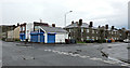
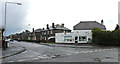
Alclutha Avenue
Fast food shops at Crosslet Road, with Alclutha Avenue on the right.
Image: © Thomas Nugent
Taken: 27 Apr 2015
0.07 miles
4
Alclutha Avenue
Bargain Store licensed grocer is on the corner of Crosslet Road.
Image: © Thomas Nugent
Taken: 27 Apr 2015
0.08 miles
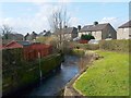
5
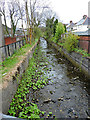
Gruggies Burn
Viewed from the bridge on Alclutha Avenue.
Image: © Thomas Nugent
Taken: 27 Apr 2015
0.09 miles
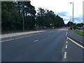
6
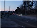
Stirling Road at dusk
The junction of Stirling Road and Dunbritton road is in the foreground. The road here known as Stirling Road is part of the long thoroughfare that carries travellers from the centre of Glasgow to Loch Lomond and on to all of Scotland west and north. It is always more or less always busy, here at dusk just as at most other times.
Image: © Alec MacKinnon
Taken: 4 Mar 2012
0.09 miles
7
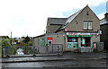
Silverton Post Office
On Alclutha Avenue. Gruggies Burn can be seen on the left.
Image: © Thomas Nugent
Taken: 27 Apr 2015
0.11 miles
8
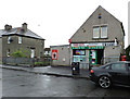
Silverton Post Office
On Alclutha Avenue.
Image: © Thomas Nugent
Taken: 27 Apr 2015
0.11 miles
9
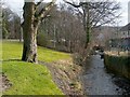
Gruggies Burn
For more information about the burn itself, see Image
The present photograph is a view towards the point where the burn passes under the main road (Stirling Road); the arch of the bridge there is visible ahead.
In the left-hand side of the photo, the course of the road is indicated by the stone wall, which is at the far side of the road. Visible on the right are the back gardens of houses in Strowan's Road; for the origin of the name of that road, see Image
For a view in the opposite direction from the same point, see Image
Image: © Lairich Rig
Taken: 24 Feb 2011
0.11 miles