IMAGES TAKEN NEAR TO
Round Riding Road, DUMBARTON, G82 2HB
Introduction
This page details the photographs taken nearby to Round Riding Road, G82 2HB by members of the Geograph project.
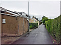
The Geograph project started in 2005 with the aim of publishing, organising and preserving representative images for every square kilometre of Great Britain, Ireland and the Isle of Man.

There are currently over 7.5m images from over14,400 individuals and you can help contribute to the project by visiting https://www.geograph.org.uk
Image Map
Images are licensed for reuse under creativecommons.org/licenses/by-sa/2.0
Notes
- Clicking on the map will re-center to the selected point.
- The higher the marker number, the further away the image location is from the centre of the postcode.
Image Listing (35 Images Found)
Images are licensed for reuse under creativecommons.org/licenses/by-sa/2.0
Image
Details
Distance
1
The start of Boghead Road
Image is in the foreground. The nearest house is called Balclutha Lodge; after the death of his first wife, and his subsequent remarriage, nineteenth-century local historian Donald MacLeod (Image) lived there.
Image: © Lairich Rig
Taken: 3 Feb 2017
0.03 miles
2
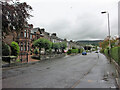
Round Riding Road, Dumbarton
Looking east from close to the junction with Boghead Road.
Image: © Richard Dorrell
Taken: 11 Aug 2021
0.04 miles
3
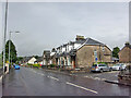
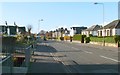
Bonhill Road, Dumbarton
Looking north, with junction with Alexander Street on the right.
Image: © Richard Dorrell
Taken: 11 Aug 2021
0.10 miles
4
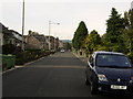
Boghead Road, Dumbarton
This stretch of Boghead Road in suburban Dumbarton is very narrow and has no pedestrian pavement. Nevertheless, the road is the sole access to a number of residential properties.
Image: © Richard Dorrell
Taken: 11 Aug 2021
0.11 miles
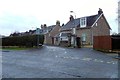
5
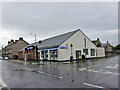
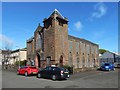
Co-op Funeralcare, Dumbarton
Funeral directors located in Bonhill Road, on the corner of Poindfauld Terrace.
Image: © Richard Dorrell
Taken: 11 Aug 2021
0.11 miles
6
Round Riding Road
The same road is shown in Image; see that item for further information. The present photograph is a view in the opposite direction, and the next turning on the left is for Miller Court. In the fenced-off area to the left, between pavement and houses, the Knowle Burn flows parallel to the road.
Image: © Lairich Rig
Taken: 1 Nov 2011
0.12 miles
7
Bonhill road, Dumbarton
Looking towards the town centre.
Image: © Stephen Sweeney
Taken: 23 Aug 2007
0.13 miles
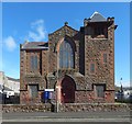
9
Dumbarton Free High Church
This view shows Image just to the left of the church.
Image: © Lairich Rig
Taken: 10 Apr 2017
0.15 miles