IMAGES TAKEN NEAR TO
Bonhill Road, DUMBARTON, G82 2DX
Introduction
This page details the photographs taken nearby to Bonhill Road, G82 2DX by members of the Geograph project.
The Geograph project started in 2005 with the aim of publishing, organising and preserving representative images for every square kilometre of Great Britain, Ireland and the Isle of Man.

There are currently over 7.5m images from over14,400 individuals and you can help contribute to the project by visiting https://www.geograph.org.uk
Image Map
Images are licensed for reuse under creativecommons.org/licenses/by-sa/2.0
Notes
- Clicking on the map will re-center to the selected point.
- The higher the marker number, the further away the image location is from the centre of the postcode.
Image Listing (39 Images Found)
Images are licensed for reuse under creativecommons.org/licenses/by-sa/2.0
Image
Details
Distance
1
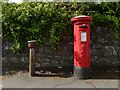
Pillar box and old drinking fountain
In the angle where Bonhill Road and Townend Road meet, an E VII R pillar box stands beside a "Glenfield" drinking fountain.
See Image for context. The same area is left of centre behind the roundabout in Image
Image: © Lairich Rig
Taken: 10 May 2019
0.01 miles
2
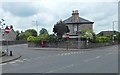
Townend Road and Bonhill Road
Townend Road is the nearer of the two. The roads meet on the approach to Image A Image can be seen not far ahead.
Image: © Lairich Rig
Taken: 8 Jul 2019
0.02 miles
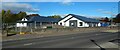
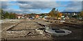
5
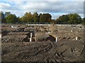
Langcraigs Care Home construction site
The picture was taken from beside Townend Road. For the opposite view, see Image, taken on the same day from the other side.
Image: © Lairich Rig
Taken: 20 Oct 2019
0.06 miles
7
Demolition of Langcraigs residential care home
Compare the equivalent view three weeks later: Image The other side was still largely intact: Image A new care home is to be built on this site.
Image: © Lairich Rig
Taken: 19 Apr 2019
0.06 miles
8

Demolition of Langcraigs residential care home
Compare the equivalent scene three weeks earlier: Image A new care home is to be built on this site.
Image: © Lairich Rig
Taken: 10 May 2019
0.06 miles
9
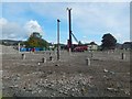
Cleared site of Langcraigs Care Home
The main road (Townend Road) is behind the site. See Image for a view from that side. The building that used to stand here is shown in Image
Image: © Lairich Rig
Taken: 1 Sep 2019
0.07 miles
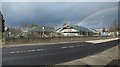
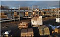
10
Langcraigs Care Home construction site
The view is over the boundary fence rather than from inside it. For views from the left and right, see, respectively, Image and Image In the present picture, Townend Road is on the right. The nearer houses on the left are on Gooseholm Road, while those in the background are in Bellsmyre. The Long Crags (or Lang Craigs) which gave the care home its name are in the right background.
Image: © Lairich Rig
Taken: 20 Oct 2019
0.07 miles