IMAGES TAKEN NEAR TO
Overburn Avenue, DUMBARTON, G82 2BQ
Introduction
This page details the photographs taken nearby to Overburn Avenue, G82 2BQ by members of the Geograph project.
The Geograph project started in 2005 with the aim of publishing, organising and preserving representative images for every square kilometre of Great Britain, Ireland and the Isle of Man.

There are currently over 7.5m images from over14,400 individuals and you can help contribute to the project by visiting https://www.geograph.org.uk
Image Map
Images are licensed for reuse under creativecommons.org/licenses/by-sa/2.0
Notes
- Clicking on the map will re-center to the selected point.
- The higher the marker number, the further away the image location is from the centre of the postcode.
Image Listing (22 Images Found)
Images are licensed for reuse under creativecommons.org/licenses/by-sa/2.0
Image
Details
Distance
1

Former bonded warehouses
The buildings on the right were part of the very extensive J&B plant. See Image for the opposite view.
BBC Scotland now has studios on the site, and some programmes are filmed here. Other land that formerly made up the J&B plant has become part of the Lomondgate development.
Image: © Lairich Rig
Taken: 29 Aug 2020
0.06 miles
2
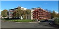
Overburn Avenue and Park Crescent
Image is on the right; that picture shows it before this work took place. Comparison of the present picture with Image, taken shortly after the completion of the work, shows that the buildings on Overburn Avenue were also included in the work.
Image: © Lairich Rig
Taken: 14 Oct 2018
0.07 miles
3
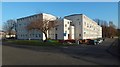
Overburn Avenue and Park Crescent
For the change in appearance of these buildings, compare the present picture with Image, taken while work was in progress, and with Image, taken a few years earlier.
Image: © Lairich Rig
Taken: 17 Nov 2018
0.07 miles
4
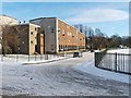
Park Crescent
Park Crescent is shown here from the point where it leaves Overburn Avenue, part of which is visible in the foreground; compare the later Image, a wider view.
The red sandstone building visible through the trees at the end of the road is Braehead Primary School.
Work took place on the buildings of Park Crescent in 2018. It is shown during that work in Image, and shortly after its completion in Image
Image: © Lairich Rig
Taken: 8 Jan 2010
0.08 miles
5
Former bonded warehouses
The buildings on the left were part of the very extensive J&B plant. See Image for the opposite view.
BBC Scotland now has studios on the site, and some programmes are filmed here. Other land that formerly made up the J&B plant has become part of the Lomondgate development.
Image: © Lairich Rig
Taken: 29 Aug 2020
0.10 miles
6
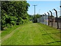
Path to Overburn Avenue
This start of this short route (500 yards long) is signposted at the junction shown in Image; the first part of the path is shown in Image
The photograph was taken from a location about halfway along the path, which ends at the point from which Image was taken. On the right, on the other side of the fence, part of Broadmeadow Industrial Estate is visible.
See Image for a view in the opposite direction.
Image: © Lairich Rig
Taken: 17 Jun 2010
0.11 miles
7
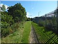
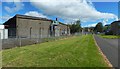
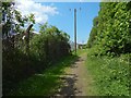
Path to Overburn Avenue
The view is from about 270 metres along the path shown (from its start) in Image; in other words, about two-thirds of the way to Overburn Avenue, as comparison with the 1:25000 map will reveal.
Behind the fence on the right is part of Broadmeadow Industrial Estate, specifically, the part of it between Birch Road and Elm Road (all of the industrial estate's roads are named after trees).
Not much further ahead, the path ends where it meets Overburn Avenue, in the area shown in Image
See Image for a view in the opposite direction.
Image: © Lairich Rig
Taken: 31 Aug 2017
0.11 miles
8
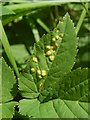
Leaf galls on Ground-elder
The plants were in the area shown just to the left (north) of the path in Image
These pale yellowish lumps in the leaf-blade of Ground-elder (Aegopodium podagria) are galls caused by the fungus Puccinia aegopodii.
Smaller, dark (but shiny) dots can be seen on some of them; they were much more abundant on the underside. These dark spots might easily be taken for eggs or larvae, but they are telia (singular "telium"), a reproductive structure produced by the fungus. Fungi often produce several distinct kinds of spores, and telia produce a kind known as teliospores.
There were quite a few examples of this gall alongside the path. The identification guide "British Plant Galls" (2ed; Redfern & Shirley, 2011) notes that this gall is "probably common but overlooked".
Image: © Lairich Rig
Taken: 25 May 2018
0.13 miles
9
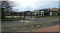
Elm Road Depot
This council depot is located on the western side of Elm Road, in Broadmeadow Industrial Estate.
Image: © Lairich Rig
Taken: 1 Jan 2012
0.13 miles
10
Path to the River Leven
Followed in this direction, the path leads from Overburn Avenue to the River Leven, with Broadmeadow Industrial Estate to the left (south) and the course of Dumbarton Golf Club to the right.
See Image and Image for views in the opposite direction.
Image: © Lairich Rig
Taken: 25 May 2018
0.17 miles