IMAGES TAKEN NEAR TO
Townend Road, DUMBARTON, G82 2BA
Introduction
This page details the photographs taken nearby to Townend Road, G82 2BA by members of the Geograph project.
The Geograph project started in 2005 with the aim of publishing, organising and preserving representative images for every square kilometre of Great Britain, Ireland and the Isle of Man.

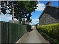
There are currently over 7.5m images from over14,400 individuals and you can help contribute to the project by visiting https://www.geograph.org.uk
Image Map
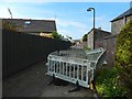
Images are licensed for reuse under creativecommons.org/licenses/by-sa/2.0
Notes
- Clicking on the map will re-center to the selected point.
- The higher the marker number, the further away the image location is from the centre of the postcode.
Image Listing (42 Images Found)
Images are licensed for reuse under creativecommons.org/licenses/by-sa/2.0
Image
Details
Distance
1
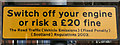
Traffic sign
On Meadow Road, at Braehead Primary School.
Image: © Thomas Nugent
Taken: 18 Mar 2011
0.10 miles
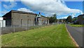
2
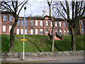
Braehead Primary School
Overlooking Meadow Park.
Image: © Thomas Nugent
Taken: 18 Mar 2011
0.10 miles
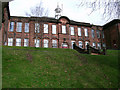
3

Braehead Primary School
A traditional Dumbarton School Board building on Meadow Road.
Image: © Thomas Nugent
Taken: 18 Mar 2011
0.10 miles
4
Braehead Primary School
On a brae overlooking Meadow Park.
Image: © Thomas Nugent
Taken: 18 Mar 2011
0.10 miles
5
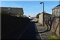
Path to Chapelton Avenue
The path had recently been resurfaced, as is revealed by comparison with two earlier pictures, one taken during work on gas infrastructure, and the other after that work was finished: Image / Image
Image: © Lairich Rig
Taken: 22 Mar 2020
0.11 miles
6
Path to Chapelton Avenue
The view is as in Image, but after the works shown there were complete. The path was later resurfaced: Image
Image: © Lairich Rig
Taken: 21 Jun 2018
0.11 miles
7
Path to Chapelton Avenue
Work was taking place on gas infrastructure. The view is from where the path leaves Bonhill Road. For a later view, after the completion of the work, see Image
Image: © Lairich Rig
Taken: 18 May 2018
0.11 miles
8
Former bonded warehouses
The buildings on the left were part of the very extensive J&B plant. See Image for the opposite view.
BBC Scotland now has studios on the site, and some programmes are filmed here. Other land that formerly made up the J&B plant has become part of the Lomondgate development.
Image: © Lairich Rig
Taken: 29 Aug 2020
0.12 miles
9
Park Crescent
Park Crescent is shown here from the point where it leaves Overburn Avenue, part of which is visible in the foreground; compare the later Image, a wider view.
The red sandstone building visible through the trees at the end of the road is Braehead Primary School.
Work took place on the buildings of Park Crescent in 2018. It is shown during that work in Image, and shortly after its completion in Image
Image: © Lairich Rig
Taken: 8 Jan 2010
0.13 miles
10
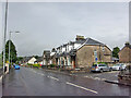
Bonhill Road, Dumbarton
Looking north, with junction with Alexander Street on the right.
Image: © Richard Dorrell
Taken: 11 Aug 2021
0.14 miles