IMAGES TAKEN NEAR TO
Castle Street, DUMBARTON, G82 1QS
Introduction
This page details the photographs taken nearby to Castle Street, G82 1QS by members of the Geograph project.
The Geograph project started in 2005 with the aim of publishing, organising and preserving representative images for every square kilometre of Great Britain, Ireland and the Isle of Man.

There are currently over 7.5m images from over14,400 individuals and you can help contribute to the project by visiting https://www.geograph.org.uk
Image Map
Images are licensed for reuse under creativecommons.org/licenses/by-sa/2.0
Notes
- Clicking on the map will re-center to the selected point.
- The higher the marker number, the further away the image location is from the centre of the postcode.
Image Listing (449 Images Found)
Images are licensed for reuse under creativecommons.org/licenses/by-sa/2.0
Image
Details
Distance
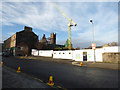
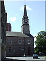
1
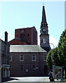
Church Street
Looking south towards Riverside parish Church Image and the old distillery tower.
Image: © Thomas Nugent
Taken: 21 Aug 2010
0.01 miles
2
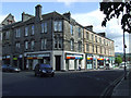
Church Street and castle Street
Church Street is on the left.
Image: © Thomas Nugent
Taken: 21 Aug 2010
0.01 miles
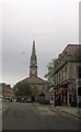
3
Castle Street, Dumbarton
This photograph was taken from about the same point as Image, but is a view in the opposite direction.
Looming large on the left are the Image Image (Image) is on the right. Between them is a lower building, with a continuous row of windows around its upper part; these are the church halls that were built c.1972, after much of the old churchyard was cleared to make space for them, as described at http://www.geograph.org.uk/article/Dumbarton-Cemetery#reduction-in-size
A lower structure is just visible in front of the left-hand side of the church halls; this is the location of Image and an adjacent vault which was originally for the Campbells of Barnhill; see http://www.geograph.org.uk/article/Dumbarton-Cemetery#surviving-memorials for more details.
Image: © Lairich Rig
Taken: 10 Nov 2011
0.01 miles
4
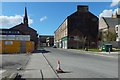
Castle Street, Dumbarton
This is the western end of the street. An earlier picture shows it from further back: Image Much has changed since that picture was taken: the last Image have been demolished (Image / Image), and Image have been built to the right (north) of the road.
Image is in the left background, with its church hall in front of it. The outline of a demolished building can be seen on the end-wall just right of centre.
Image: © Lairich Rig
Taken: 31 Mar 2019
0.01 miles
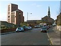
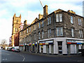
5
Castle Street
The construction at Dumbarton Burgh Hall dominates the scene.
Image: © Thomas Nugent
Taken: 5 Jan 2017
0.02 miles
7
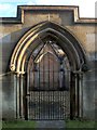
The Napier Vault
The photograph shows the entrance to one of the private lairs that are located at the eastern end of the kirkyard of Image; see Image for context, and http://www.geograph.org.uk/article/Dumbarton-Cemetery#the-parish-churchyard for more on the kirkyard.
As explained there, the kirkyard has been greatly reduced in size from its original extent, so that only few stones are now visible outside of the private lairs (see Image for a typical example of the gravestones, mainly from the early eighteenth century, which previously filled the kirkyard).
As for the private lairs, the southernmost one is the Barnhill Vault, which was originally for the Campbells of Barnhill (on whom, see Image); it now contains Image and Image, which were moved here later on. The Napier Vault, the Gothic mausoleum enclosure that is shown in the present photograph, is adjacent to it on the north (its year of construction is given above the entrance).
The middle panel of the Napier Vault (the panel that is visible through the gate) bears the following inscription:
"ROBERT NAPIER second son of JAMES NAPIER & JEAN EWING
died at West Shandon on the Gareloch in the year 1876
in the 86th year of his age.
ISABELLA NAPIER his wife died at West Shandon in the year 1875
in the 83rd year of her age.
DAVID their fourth son died at Row in the year 1833
in the second year of his age & was buried there.
ROBERT their third son died at West Shandon in the year 1848
in the 20th year of his age."
[The place then called Row is now called Rhu (Image); both spellings are pronounced "Roo".]
In mentioning West Shandon, the inscription refers to West Shandon House, a mansion which stood at about Image The building was designed by J.T.Rochead, and was built for the Robert Napier who is named first in the inscription. It was completed in about 1852, and latterly became a hydropathic institution, before being demolished in the 1950s; see https://canmore.org.uk/site/180943/west-shandon-house (at Canmore) for details.]
The late Brian D. Osborne, who was a contributor to Geograph ( http://www.geograph.org.uk/profile/2117 ), would have been better qualified to discuss the life of Robert Napier, but I can refer readers to his booklet 'Robert Napier, 1791-1876 "The Father of Clyde Shipbuilding"' for further details. See Image for one of Napier's creations.
Regarding Robert Napier's death, the booklet just cited mentions that his body was brought by road from Shandon "where ships at anchor flew their flags at half mast, through Helensburgh, where the streets were lined and the bells of the three town churches tolled for an hour. Fourteen hundred of his firm's workmen came from Glasgow and Govan by special train to Dalreoch and accompanied the coffin for the last mile to its burying place".
Historically, another Napier family was also prominent in this area; see Image
Image: © Lairich Rig
Taken: 22 Nov 2010
0.02 miles
8
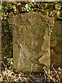
The Drysdale Memorial
This stone is one of the small number that survive in the old parish kirkyard of Image On account of its situation, the stone is sometimes overgrown; on the occasion of the present photograph, it had recently been exposed to view, and was sunlit. The stone is now rather worn, but the adjacent plaque supplies the missing details. This stone was missed during the 1969 survey of the kirkyard (carried out shortly before most of the existing stones were cleared away to make room for the new church halls), and it was only discovered a little later when ivy was cleared from this wall.
The stone was erected by William Drysdale, plumber, who died 26th March 1856, aged 48, and it commemorates Romeo Drysdale, his father, who died 23rd of ... aged 84; Margaret Haggard, his mother, who died 30th April 1848, aged 73; Margaret, his sister, who died 16th June 1848, aged 29; Ilay, his brother, died 14th July 1851, aged 35.
The father, Romeo Drysdale, is of interest: in 1810, he was appointed master gunner at Dumbarton Castle. He still held that post in 1849, when he died at the age of 84. This may seem unusual, but he was not engaged in active military duties: the infantry soldiers in the barracks at Dumbarton Castle at that time did not perform duties connected with the Castle, "nor were the veteran artillerymen actively engaged either but instead conducted visitors round the castle, expecting a gratuity in return".
His role may not have been an active military one, but it was not an insignificant one either: there was no lieutenant-governor at the Castle after 1836, and no governor after 1843, so that Romeo Drysdale and his successors as master gunner were "nominally in charge for the rest of the century".
For further details, see pages 153 and 156 of I.M.M.MacPhail's "Dumbarton Castle" (1979), from which the above quotes were taken.
- - • - -
Along the same wall, to the right of this stone, are two others, similar in size and shape, which I have not shown separately.
The first of these was (according to its inscription, which is, at the time of writing, still entirely legible) "erected to the memory of John Gaskell, son of Henry L Gaskell esquire of Southworth House, Wigan, Lancashire, who died 25th July 1837, aged 25 years".
To the right of that is another stone, whose surface has almost entirely flaked away, so that only "COTT" (part of a surname) is legible at the upper right. A nearby metal plaque records that the stone commemorates Peter H Mitchell and his wife Grace Scott. However, the plaque appears to give the wrong year for P H Mitchell's death; for further details, see the accompanying description for a picture of the Image That memorial is not located here, but in Dumbarton Cemetery. Robert Glassford Mitchell was Peter H Mitchell's only son, the issue of his second marriage.
Image: © Lairich Rig
Taken: 4 Jan 2013
0.02 miles
9
Riverside Parish Church
At the junction of Church Street, High Street and Castle Street. See also Image
Image: © Thomas Nugent
Taken: 21 Aug 2010
0.02 miles
10
Church Street at Castle Street
Looking towards the Dumbarton Burgh Hall construction site, Castle Street is to the right.
Image: © Thomas Nugent
Taken: 5 Jan 2017
0.02 miles