IMAGES TAKEN NEAR TO
Leven Street, DUMBARTON, G82 1QG
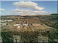
Introduction
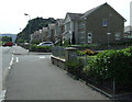
This page details the photographs taken nearby to Leven Street, G82 1QG by members of the Geograph project.
The Geograph project started in 2005 with the aim of publishing, organising and preserving representative images for every square kilometre of Great Britain, Ireland and the Isle of Man.

There are currently over 7.5m images from over14,400 individuals and you can help contribute to the project by visiting https://www.geograph.org.uk
Image Map
Images are licensed for reuse under creativecommons.org/licenses/by-sa/2.0
Notes
- Clicking on the map will re-center to the selected point.
- The higher the marker number, the further away the image location is from the centre of the postcode.
Image Listing (189 Images Found)
Images are licensed for reuse under creativecommons.org/licenses/by-sa/2.0
Image
Details
Distance
1

Wallace Street
With Denny Road in the background. Viewed from Glasgow Road.
Image: © Thomas Nugent
Taken: 24 Apr 2011
0.03 miles
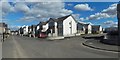
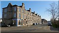
2
Denny Crescent, Dumbarton
This street is part of the Castle Quay housing development. The name Denny Crescent commemorates the former presence here of the northern part of Denny's shipyard. At a still earlier period, and as shown on the first-edition OS map (surveyed in 1860), this northern part had previously been the site of the Victoria Yard (of Denny & Rankin): see Image
(For the company Denny & Rankin, see the comments at http://www.geograph.org.uk/article/Dumbarton-Cemetery#shipbuilding-and-other-industries on Peter Denny of Castlegreen and on Daniel Rankin. For the place-name Castlegreen, see comments on Image)
Image: © Lairich Rig
Taken: 21 Feb 2013
0.03 miles
3
Denny Road
Housing on a former industrial site off Castle Road.
Image: © Thomas Nugent
Taken: 12 Jul 2013
0.04 miles
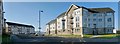
4

Victoria Street
Looking towards Castle Road and Dumbarton Rock and castle beyond.
Image: © Richard Sutcliffe
Taken: 1 Sep 2023
0.04 miles
5

Castlegreen Street
Victoria Street is to the right.
Image: © Thomas Nugent
Taken: 12 Jul 2013
0.05 miles
6
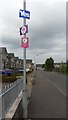
Yes or no, don't poo on the pavement...
Scottish Referendum posters and a more official sign on Castle Road, Dumbarton.
Image: © Peter Whatley
Taken: 16 Sep 2014
0.05 miles
7
View from the castle
Looking NE up Victoria Street. Whisky warehouses no longer exist with new development on left and nothing (yet) on the right.
Image: © tony ferrie
Taken: 14 Apr 2008
0.07 miles
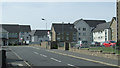
8
Castle Road
Leading to Dumbarton Rock and Dumbarton Castle.
Image: © Thomas Nugent
Taken: 12 Jul 2013
0.07 miles
9
Castlegreen Street, Dumbarton
The picture was taken from near the junction with Victoria Street, which appears in the foreground. The road receding from the photographer's position is Castlegreen Street.
As shown, for example, on the first-edition OS map (surveyed in 1860), the area known as Castle Green was just to the north of nearby Dumbarton Rock.
The area was long known as Castle Green, in reference to Dumbarton Castle – http://www.geograph.org.uk/article/Dumbarton-Rock-and-Castle – but by 1860, there was a house called Castle Green there, at Image; the house is depicted on the first-edition OS map (the western half of the stand and facilities of the stadium of Image are at about the same spot).
The house was the seat of a branch of the Denny family: see Image Peter Denny of Castlegreen was Provost of Dumbarton from 1834-44, and from 1848-51.
The name Castle Green is considerably older; for example, it is found in an Act of Parliament, passed on the 5th of August, 1704, entitled "Act of dissolution of the feu duties of Bute and other rents allocated to the keeping of the castle of Dumbarton and the constabulary thereof". The act mentions the "ferme and watchmail of Kilpatrick, mains and feu-duties of Cardross, with the castle green". (As an aside, the watchmeal of Kilpatrick – as the term is usually spelled – was an ancient tax originally levied to fund measures to ward off wolves: see Image for references to further information).
Image: © Lairich Rig
Taken: 21 Feb 2013
0.07 miles