IMAGES TAKEN NEAR TO
Castle Road, DUMBARTON, G82 1JJ
Introduction
This page details the photographs taken nearby to Castle Road, G82 1JJ by members of the Geograph project.
The Geograph project started in 2005 with the aim of publishing, organising and preserving representative images for every square kilometre of Great Britain, Ireland and the Isle of Man.

There are currently over 7.5m images from over14,400 individuals and you can help contribute to the project by visiting https://www.geograph.org.uk
Image Map
Images are licensed for reuse under creativecommons.org/licenses/by-sa/2.0
Notes
- Clicking on the map will re-center to the selected point.
- The higher the marker number, the further away the image location is from the centre of the postcode.
Image Listing (288 Images Found)
Images are licensed for reuse under creativecommons.org/licenses/by-sa/2.0
Image
Details
Distance
1
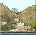
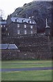
Dumbarton Castle
Site of the ancient capital of Strathclyde, Mary Queen of Scots sailed to France from here as a child in 1548.
Image: © JThomas
Taken: 25 Aug 2005
0.00 miles
2
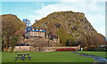
Dumbarton Castle
Undergoing some restoration. http://www.historic-scotland.gov.uk/propertyresults/propertyoverview.htm?PropID=pl_100&PropName=Dumbarton%20Castle
Image: © wfmillar
Taken: 6 Dec 2011
0.00 miles
4
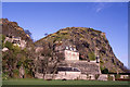
Dumbarton Rock and Castle
Solid defensive walls complement the natural defences offered by the rock itself.
Image: © Thomas Nugent
Taken: 12 Jul 2013
0.01 miles
5
Dumbarton Castle
Viewed from across the Clyde at Westferry.
Image: © Thomas Nugent
Taken: 10 Dec 2007
0.01 miles
6
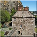
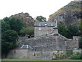
Dumbarton Rock: The Governor's House
[This is one of a linked series of articles about Dumbarton Rock. See the end of http://www.geograph.org.uk/photo/1380091 for a list of the reference works that are cited here in abbreviated form.]
The building shown here serves as a ticket office for Dumbarton Castle, and as a museum. Like King George's Battery, the Governor's House was built in 1735 (John, 8th Earl of Cassillis, was the governor of the castle at that time) [MacPhail, p144].
The house was built upon the site of the medieval gatehouse, which had likewise housed the governors of the castle from early times [OSG92, p11].
Little is known about the history of occupation and fortification on the Rock between the sacking of a fortress here by Viking forces in 870 and the building of the first medieval castle. However, among the exhibits on display in the Governor's House are fragments of two tenth-century recumbent cross-slabs (Image).
They were found in the lower slopes just behind the house, an area that is the traditional location of an early chapel of St Patrick; the fragments may have been associated with that chapel, or they may have brought from elsewhere [HD, p11, 18, 73].
Previous: Image
Next: Image
Image: © Lairich Rig
Taken: 26 Jun 2009
0.01 miles
8
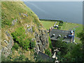
Dumbarton Rock and Castle
Looking down the cleft between the two peaks.
Image: © Thomas Nugent
Taken: 12 Jul 2013
0.01 miles
9
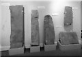
Dumbarton Castle: ancient stones
The stones are on display in the Governor's House (Image). Several were recumbent grave-slabs, dating variously from the 10th to 14th centuries, and stylistically similar to others found in the Govan area. An exception is the stone at the lower right, which was inscribed in 1704.
The stone at the far left has carved on it the base and part of the shaft of a cross, but also features scissors at its upper right.
Image: © Lairich Rig
Taken: 5 Nov 2014
0.01 miles
10
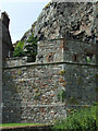
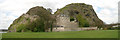
Dumbarton Castle
A Scheduled Ancient Monument and Category A listed building.
Image: © Richard Sutcliffe
Taken: Unknown
0.01 miles