IMAGES TAKEN NEAR TO
Buchanan Street, DUMBARTON, G82 1JA
Introduction
This page details the photographs taken nearby to Buchanan Street, G82 1JA by members of the Geograph project.
The Geograph project started in 2005 with the aim of publishing, organising and preserving representative images for every square kilometre of Great Britain, Ireland and the Isle of Man.

There are currently over 7.5m images from over14,400 individuals and you can help contribute to the project by visiting https://www.geograph.org.uk
Image Map
Images are licensed for reuse under creativecommons.org/licenses/by-sa/2.0
Notes
- Clicking on the map will re-center to the selected point.
- The higher the marker number, the further away the image location is from the centre of the postcode.
Image Listing (139 Images Found)
Images are licensed for reuse under creativecommons.org/licenses/by-sa/2.0
Image
Details
Distance
1
Gruggies Burn at Buchanan Street
The burn here runs parallel to Buchanan Street, which is on the left, behind the wall. It is probably safe to assume(*) that the street was named after Dr Buchanan (d.1871; see Image), who lived in nearby Knoxland House (now gone; see Image).
(*) In this connection, I consulted the cuttings in Dumbarton Library: they do not give the reason for the name Buchanan Street, but they do mention that it was known as Boundary Street until at least 1901.
Image: © Lairich Rig
Taken: 16 Oct 2015
0.02 miles
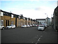
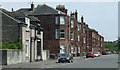
2
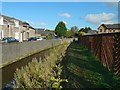
Bruce Street
Terraced cottages at the east side of Knoxland Square.
Image: © Thomas Nugent
Taken: 12 Jul 2013
0.02 miles
3
Knoxland Street, Dumbarton
Off Bruce Street.
Image: © Richard Vince
Taken: 13 Sep 2022
0.03 miles
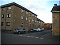
4
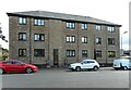
Flats on Bruce Street
Built on the site of the former Knoxland Parish Church.
Image: © Richard Sutcliffe
Taken: 1 Sep 2023
0.03 miles
5
Bruce Street, Dumbarton
Seen from its southern junction with Knoxland Square.
Image: © Richard Vince
Taken: 13 Sep 2022
0.03 miles
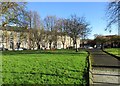
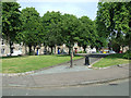
7
Knoxland Square
There is a garden in the middle of the square.
See Image for details of the history of the square.
Image: © Thomas Nugent
Taken: 12 Jul 2013
0.05 miles
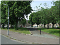
8
Knoxland Square
Knoxland Square was presented to the town of Dumbarton by Dr Peter Denny of Helenslee, on Saturday the 10th of May, 1890 (on Peter Denny, see Image and Image).
A great deal of ceremony accompanied the presentation: various groups converged first on Levengrove Park (see http://www.geograph.org.uk/snippet/5911 for details of the park, which had likewise been gifted to the town in 1885). There, they were organised into a procession that crossed Image, and which then followed the town's High Street, Castle Street, and Glasgow Road, before arriving here.
At that time, there was a bandstand in Knoxland Square; from there, Peter Denny delivered his speech. Provost Babtie accepted the Square on behalf of the town; Peter Denny was, in turn, presented with a decorated casket.
The only condition that Mr Denny had attached to the presentation of Knoxland Square to the town was that no political meetings or "discussions of a controversial character" should take place there.
[For a detailed account of the groups making up the procession, of the speeches delivered, and of the other events of the day, see Donald MacLeod's "Dumbarton: Its Recent Men and Events" (1898). Knoxland Square was also the subject of a "Dumbarton Remembered" feature, written by Mike Taylor, in the Lennox Herald issue of January 8, 2010; that item also describes some of the subsequent changes to the square.]
The bandstand mentioned above was removed in 1948, when the present-day park that occupies the square was laid out.
The name Knoxland (see Image for a possible origin) was associated with this area before the Square was built. The area is in Dumbarton's so-called New Town(*), as opposed to the older part of the town, which is further to the west (where the town centre is located on what had been the heart of the medieval burgh).
[(*) As a note on current usage, I should add that I don't know of anyone locally who talks about the "New Town" (unless in a historic context, as in this item, where I am simply using the names that were employed at the time of the events being described). For my part, I always call this whole general area "Dumbarton East" (which is also the name of the railway station), unless referring to more specific areas (for example, Silverton). I suspect that most people do the same.]
The first-edition OS map (c.1860) shows the Knoxland area as it was before the New Town was developed. The grid of streets that is now located in this area did not then exist; instead, there was a group of buildings, named Knoxland on the map. From the 1820s onwards, there are several mentions of Knoxland and its occupant in contemporary writings; it had been the residence of a Dr Robert Buchanan (d. Sep 1871), who served as a general practitioner for about fifty years: Image (a description of the long-vanished Knoxland House can also be found at that item).
For a view of the opposite corner of the Square, see Image, which was taken a few weeks later. That part of it lies in the adjacent OS grid square to the north.
Other views: Image / Image / Image / Image
Image: © Lairich Rig
Taken: 10 Nov 2011
0.06 miles
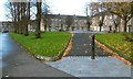
9
Knoxland Square
There is a garden in the middle of the square. See Image for details of the history of the square
Image: © Thomas Nugent
Taken: 12 Jul 2013
0.06 miles
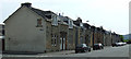
10
Castlegreen Street
Looking east near the junction with Bruce Street.
Image: © Thomas Nugent
Taken: 12 Jul 2013
0.06 miles