
IMAGES TAKEN NEAR TO
Rock Place, DUMBARTON, G82 1DB
Introduction
This page details the photographs taken nearby to Rock Place, G82 1DB by members of the Geograph project.
The Geograph project started in 2005 with the aim of publishing, organising and preserving representative images for every square kilometre of Great Britain, Ireland and the Isle of Man.

There are currently over 7.5m images from over14,400 individuals and you can help contribute to the project by visiting https://www.geograph.org.uk
Image Map
Images are licensed for reuse under creativecommons.org/licenses/by-sa/2.0
Notes
- Clicking on the map will re-center to the selected point.
- The higher the marker number, the further away the image location is from the centre of the postcode.
Image Listing (320 Images Found)
Images are licensed for reuse under creativecommons.org/licenses/by-sa/2.0
Image
Details
Distance
1
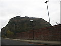
Looking towards the Dumbarton Rock
From Castle Street adjacent to the football stadium.
Image: © James Denham
Taken: 24 Nov 2013
0.03 miles
2
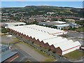
The former Blackburn Aircraft Factory
Construction of these factory buildings began in 1937, as a result of a business partnership between Sir Maurice Denny, Managing Director of the Dumbarton firm Denny Shipbuilders, and Robert Blackburn, of Yorkshire's Blackburn Aeroplane and Motor Company. The site on which the factory stood was called Barge Park; completed machines would be taken across the River Clyde by barge to Abbotsinch airfield.
Aircraft built here included the Blackburn Shark B6 Mark III (a torpedo/spotter/reconnaissance biplane, assembled from components manufactured in Yorkshire), the Short Sunderland (a flying boat patrol bomber, built entirely at this site), and many others.
By early 1961, the factory had closed. As the photo shows, the factory buildings survived rather longer, becoming part of a bottling plant. However, they have now been demolished; see Image
For a detailed history of the factory, and of the circumstances surrounding its creation, and for details of the aircraft that were produced here, the best source of information is the booklet "The Blackburn: Dumbarton's Aircraft Factory" (1996) by Alan M. Sherry.
The photograph was taken from one of the batteries of Dumbarton Castle. For views of the buildings from the road beside them, see Image and Image
Image: © Lairich Rig
Taken: 8 Aug 2005
0.04 miles
3
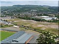
Site of the former Blackburn Aircraft Factory
For a view of the factory buildings that once stood here, see Image
For the new houses visible on the left, see Image
Image: © Lairich Rig
Taken: 26 Jun 2009
0.04 miles
4
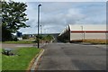
Castle Road
The large buildings on the right had once been those of the Blackburn Aircraft Factory, though they were being used by Allied Distillers when this picture was taken: they are now gone.
For a better look at the buildings, on the same day, see Image, taken from further along the road, alongside the building; that item also features some comments about the area to the left (west) of the road, where a football stadium is located.
A later view along the same road in the opposite direction also shows the old factory buildings: Image
Views from above (more specifically, from Dumbarton Rock) show the road before and after those buildings were removed: Image (before) and Image (after). In the later picture, some new housing had also appeared at the far left, on the other side of the road: for that development, see Image
Image: © Lairich Rig
Taken: 8 Aug 2005
0.04 miles
5
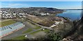
Castle Road and surroundings
This wide-angle view is intended to show developments around Castle Road. To its west (left) are the grounds of Image
Behind the stadium is the recent housing that makes up the Castle Quay development: Image
The other side (east) of the road was formerly the site of the Blackburn Aircraft Factory, later used by Allied Distillers: Image The factories shown there were later demolished. By the time the present picture was taken, a new housing development was beginning on that site: Image (see http://www.geograph.org.uk/snippet/15948 for related pictures).
Further to the right is Image
Image: © Lairich Rig
Taken: 26 Mar 2017
0.05 miles
6
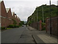
Castle Street, Dumbarton
Looking south to the Rock.
Image: © Stephen Sweeney
Taken: 2 Jun 2007
0.06 miles
7
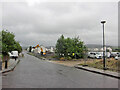
Castle Road, Dumbarton
The road ends at the castle entrance, a little behind the photographer.
A large new housing development is currently under construction.
Image: © Richard Dorrell
Taken: 11 Aug 2021
0.06 miles
8
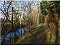
Gruggies Burn
On the other side of the burn, but obscured by trees, Image was taking shape.
Image: © Lairich Rig
Taken: 13 Dec 2019
0.07 miles
9
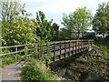
Footbridge over Gruggies Burn
This small bridge over Image is part of the Dumbarton Foreshore Walk. Below this point, the burn crosses the beach and empties into the Clyde: Image
See Image for a view from the other side.
Image: © Lairich Rig
Taken: 25 May 2012
0.07 miles
10
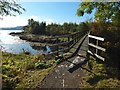
Footbridge over Gruggies Burn
The footbridge, marked on the 1:25000 map, is shown from the other side in Image The burn is shown here emptying into the Clyde.
Image: © Lairich Rig
Taken: 16 Oct 2015
0.07 miles