IMAGES TAKEN NEAR TO
Park Avenue, DUMBARTON, G82 1BU
Introduction
This page details the photographs taken nearby to Park Avenue, G82 1BU by members of the Geograph project.
The Geograph project started in 2005 with the aim of publishing, organising and preserving representative images for every square kilometre of Great Britain, Ireland and the Isle of Man.

There are currently over 7.5m images from over14,400 individuals and you can help contribute to the project by visiting https://www.geograph.org.uk
Image Map
Images are licensed for reuse under creativecommons.org/licenses/by-sa/2.0
Notes
- Clicking on the map will re-center to the selected point.
- The higher the marker number, the further away the image location is from the centre of the postcode.
Image Listing (114 Images Found)
Images are licensed for reuse under creativecommons.org/licenses/by-sa/2.0
Image
Details
Distance
1
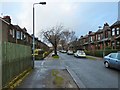
Silverton Avenue
The nearest house on the left has an inscription in a roundel beside one of its upper windows; that roundel (shown in close-up in Image) can be seen in the picture, and its inscription reads as follows:
"DUMBARTON
BUILDING SOCIETY Lᵀᴰ
ESTABLISHED 1873
───────────────
ERECTED 1923 IN
COMMEMORATION OF
JUBILEE YEAR"
Dumbarton Building Society had acquired 3¼ acres here from Dr Douglas White (for whom, see Image / Image / Image) in order to build the houses shown on the right, that is, on the eastern side of the street; they are of red sandstone construction. The memorial stone of this scheme was laid on Sat 31st Jan 1914 by Dr White.
To protect the land from flooding, a concrete wall was built on the south side of nearby Gruggies Burn (see Image, taken at the far end of this Avenue); the wall extended from the bed of the burn to one foot above road level. The cost for building the protective wall was borne by the North British Railway Company, Dr White, and the building society.
In fact, when the houses on the right were built, there was large grassy expanse in front of them (as well as the road to Silvertonhill Farm; as mentioned below, that road corresponds to the line of present-day Silverton Avenue).
The houses on the left employ red sandstone on their front only, and, as indicated by the text in the roundel, quoted above, their construction began in 1923; those houses were completed and occupied by the early part of 1925.
Compare the above inscription with Image, which can be seen 265 metres to the west, at the corner of Bruce Street and Glasgow Road. That building was called Grange Place, and it was, as the presence of that inscription implies, the work of the same building society; the building itself is shown in Image
A part is missing below the inscription: it originally said "Erected 1906". It therefore pre-dates both sides of Silverton Avenue. The name Grange Place, which is no longer employed for that building, perhaps appeared above the inscription.
Further information about these building projects (and the Society's others) can be found in the "Jubilee Souvenir of Dumbarton Building Society Ltd 1873—1923: Fifty Years' History" (James Lyon, 1923).
- - • - -
Silverton is the name of a part of Dumbarton East that grew up around the farmhouse of Silvertonhill.
The farm is recorded as "Silvertownhill" on Roy's Military Survey of Scotland (1740s—50s), as "Silartonhill" on a 1777 map by Charles Ross, and as "Silverton Hill Farm" in 1832.
The farm buildings survive in a modified form at Image, a little beyond the far end of this avenue. The L-shaped building there retains some elements of the layout shown on the second-edition map (1896/97); at that time, the buildings formed three sides of a square (N/W/S), but the northern part has since been replaced by a more modern detached structure (Hartfield Cottage), leaving the western and southern parts that form the L-shape.
The building stands beside a short lane, Silvertonhill Lane. Though now in the midst of housing, it still has, I think, something of the look of a farmhouse about it.
- - • - -
The line of Silverton Avenue is interesting in the following respect: if you were to leave Glasgow Road to follow Silverton Avenue, then, at the end of that street, cross the little footbridge over Gruggies Burn (see Image, taken from that bridge), and, finally, continue in almost the same direction along the short Silvertonhill Lane, you would be following the course of a road that is marked on the first-edition map (surveyed in 1860).
That road led from the main road (present-day Glasgow Road) to Silvertonhill Farm. Even by 1860, when the first-edition OS map was surveyed, the line of that road had been interrupted by a railway line, running NW—SE, just north of Gruggies Burn. That railway line is long gone, but its former course survives as a present-day footpath, which is also a cycle path.
Image: © Lairich Rig
Taken: 2 Dec 2017
0.04 miles
2
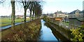
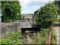
Gruggies Burn
The photograph was taken from the northern side of Glasgow Road, just a few metres from Dumbarton's Image; the park can be seen to the left of the burn. On the right are some houses and back gardens in Park Avenue.
At the photographer's position, the burn is directed below Glasgow Road, but it reappears at the other side: Image
Gruggies Burn, so called on OS maps from the first-edition (surveyed in 1860) onwards, arises from the confluence of Image and the Image, which meet at Image
According to I.M.M.MacPhail's "Dumbarton Through the Centuries" (1972), the same John Brown (Image) who built Image in 1765 "later built the bridge over Gruggie's Burn in the east of the town". The bridge would have been at the point from which my photograph was taken, but no remnants of any old bridge are now apparent there; there is simply a modern bridge taking Glasgow Road over the burn: see Image for a view of that spot, which was the site of the old bridges, and from which the present photograph was taken.
Other sources reveal that John Brown's stone bridge over Gruggies Burn was built in 1768. Dumbarton's Burgh Records for that year include the following entry: "April 10 – Gruggie's Bridge agreed to be built according to Mr Brown's plan and estimates" [that entry is reproduced in the appendix of John Glen's book "History of the Town and Castle of Dumbarton" (1847)]. In addition, page 3 of Fergus Robert's pamphlet "The Tolbooth of Dumbarton" (1938) says of John Brown that "he built Dumbarton Bridge in 1765 and in 1768 he designed and built Gruggie's Bridge, the latter costing £55 5s 6d".
This was by no means the first bridge at this spot. Roy's Military Survey of Scotland (1747-55) does not label the burn itself, but does show a bridge named after it: "Grugiesbrigg" (this pre-dates John Brown's bridge, and is probably the earlier stone bridge that is described next).
The Dumbarton Burgh Records contain an entry for July 1, 1663 (I have, in square brackets, interpreted a few of the less familiar expressions), "the quhilk [which] day it is statut and ordained that in respect of the manifold charges this burgh has been at in upholding the timber briggs at Gruggies Burn thir dyvers yeirs bygane [this past several years], and which charges might have built a stane brig, Thairfor to the effect ane stane brig may be built with ane pen [one arch] on the said burn, for the better and mare safe passage of the liedges [loyal subjects] to and from this burgh".
James Thorne, master of works, was entrusted with overseeing the construction of the new stone bridge, in which task he was to be assisted by William McK[a]y. The new bridge was "to be built all of hewne stane in the pens and above, and ... stanes may conveniently be had out of the colledge", a reference to the Collegiate Church (see Image), which had largely been torn down in the turmoil of the Reformation, and which often served thereafter as a convenient source of stone.
The previous wooden bridges, whose maintenance had proved so costly, probably dated from 1628 or later: an entry in the Burgh Records, dated April 22, 1628, reads: "Item, to lay the tries alang ower Grugie's Burn"; "tries" (trees) here has the sense of timbers or beams. The results were perhaps unsatisfactory, since, in an entry made on September 8 of the same year, it was resolved "to cause mak a brig ouer Gruggies Burn", presumably a sturdier wooden structure. (There may have been earlier bridges here, but the surviving burgh records do not extend back before April of 1627.)
[At least in the seventeenth century, Grugie was a local surname; for example, in an entry for April 15, 1651, in the Dumbarton Burgh Records, a list of names includes a certain James Grugie. Further, it seems that the surname was particularly associated with the Dumbarton area: for example, the Commissariot Record of Glasgow, Register of Testaments (1547-1800), covers a considerable part of Scotland, but includes only three people with the surname Grugie, namely, Cuthbert/Cudbert, Jonet, and James, all of whom were from Dumbarton (in fact, they were from the part of Dumbarton where this bridge would be built). This local surname seems to be the most likely explanation for the origin of the burn's name. See https://canmore.org.uk/site/43255/dumbarton-gruggies-burn (at Canmore), which comes a similar conclusion; the location to which that Canmore record refers is the point from which my photograph was taken. For the Silverton Hill Farm mentioned there (certain elements of the farmhouse survive), see my comments at Image]
Image: © Lairich Rig
Taken: 21 Jan 2011
0.04 miles
3
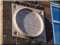
Dumbarton Building Society stone in Silverton Avenue
For context, see Image, where this inscribed tablet can be seen on the front of the nearest building on the left. The date 1923 applies only to the houses on that side (the west) of the avenue. Those on the other side were built earlier, in 1914.
Dumbarton Building Society had its origins at a special meeting of the Dumbarton Equitable Co-operative Society on the 30th of January 1873. There, Mr John Barr indicated that a number of workers at Messrs Swan's yard wished to form a building society. An interim committee was formed. At their first general meeting, on 26th February, the official committee was appointed.
The organisation was at that time called the Dumbarton Land and Buildings Investment Company. The change of name came in February 1878, when the Society came under the Building Societies' Act.
On the occasion of their Jubilee Year, a commemorative stone of polished granite, the one shown in the present picture, was built into the corner house on the west side of Silverton Avenue, nearest Glasgow Road. While it is a date stone, after a fashion, it is essentially a commemorative stone for the Society's Jubilee Year. On Saturday 1st December 1923, a ceremony was held at the building, when the stone was unveiled by Mr William A Hutchison, the president. Luncheon was then served in the Co-operative Hall, 46 High Street, Dumbarton, to which members of the Society of thirty years' membership, past members of the Committee, and officials, were invited.
The above details are from the "Jubilee Souvenir of Dumbarton Building Society Ltd 1873—1923: Fifty Years' History" (James Lyon, 1923).
Another building in Dumbarton has a stone with an inscription mentioning the Society: the stone is shown in Image, and it is built into a tenement block that was originally called Grange Place: Image Below that inscription there used to be the additional text "Erected 1906", but it has fallen off or, more likely, been removed, at some point in the intervening century and more. In addition, the name Grange Place may have appeared above the surviving inscription.
Image: © Lairich Rig
Taken: 19 Jan 2018
0.05 miles
4
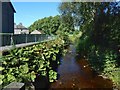
Gruggies Burn near Silverton Avenue
The view is from a little footbridge that crosses the burn just to the north of Silverton Avenue in Dumbarton East. East End Park is directly ahead; the burn turns left to head SSW along the eastern margin of the park (as shown in Image) before flowing under the main road (Image).
Image: © Lairich Rig
Taken: 24 Aug 2016
0.06 miles
5
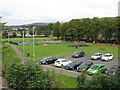
Car park & children's playground north of Dumbarton East station
Image: © Peter Whatley
Taken: 16 Sep 2014
0.06 miles
6
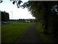
A Dumbarton cycletrack
In the 19th and early 20th century Britain's private railway companies competed vigorously but could also co-operate with one another. Hence the Caledonian and North British Railways both owned separate lines between Glasgow and Dumbarton, serving the same intermediate towns, but then jointly owned the line onward to Balloch for Loch Lomond. By the middle of the 20th century these alternative routes were described as duplication and the Caledonian route, generally keeping closer to the riverside and the Clyde shipyards, was closed. At about the same time the former North British route was electrified but west of Bowling, where the two lines came close together, a new connection was put in by British Railways and it was a section of the Caledonian line through Dumbarton East station that was electrified and the North British line that was closed. Since then the latter has become a footpath and cycleway and is seen here crossing playing fields behind Crosslet Road, a short distance east of where the joint Dumbarton and Balloch line had started.
Image: © A-M-Jervis
Taken: 13 Oct 2007
0.06 miles
7
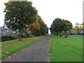
Footpath into East End Park, Dumbarton
Off Glasgow Road.
Image: © Richard Vince
Taken: 13 Sep 2022
0.06 miles
8
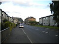
Glasgow Road, Dumbarton
Looking towards Glasgow from Gruggies Bridge.
Image: © Richard Vince
Taken: 13 Sep 2022
0.07 miles
9
Glasgow Road crossing Gruggies Burn
I saw no signs of very old structures here, but the burn used to be crossed at this point by a bridge (1768) built by John Brown (Image). Elsewhere in Dumbarton, he had already built a bridge over the Leven: Image
There had been an earlier stone bridge (c.1663) over Gruggies Burn. Before that, there had been at least one timber bridge (probably several of them in succession). See Image for more information on the burn and on all of the bridges mentioned above; that picture was taken from the modern bridge that is shown in the present photograph, and which carries Glasgow Road over the burn.
Image: © Lairich Rig
Taken: 1 Jun 2012
0.07 miles
10
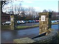
East End Park - the southern entrance
This photograph was taken from the side of Glasgow Road; the road and one of these gateposts can be seen in Image, which provides further context. As a comparison with that photograph makes clear, the course of the railway line at Dumbarton East Station can be seen in the background.
As for the gateposts, the more distant one bears the inscription: "Children's park opened January 1914".
The inscription on the nearer gatepost reads: "Gifted to the Burgh of Dumbarton by Dr J.Douglas White & Peter Denny".
For the Denny family, see Image and Image
As for Dr J. Douglas White, he was the nephew of James Campbell White, the first Lord Overtoun, who was, in turn, the son of the industrialist James White, for whom Image was built: see Image, on which all three of these individuals are commemorated, and Image
For a view of the park, as seen from almost the same spot, see Image For another part of the park, see Image
Image: © Lairich Rig
Taken: 21 Jan 2011
0.08 miles