IMAGES TAKEN NEAR TO
Otago Place, DUMBARTON, G82 1BS
Introduction
This page details the photographs taken nearby to Otago Place, G82 1BS by members of the Geograph project.
The Geograph project started in 2005 with the aim of publishing, organising and preserving representative images for every square kilometre of Great Britain, Ireland and the Isle of Man.

There are currently over 7.5m images from over14,400 individuals and you can help contribute to the project by visiting https://www.geograph.org.uk
Image Map
Images are licensed for reuse under creativecommons.org/licenses/by-sa/2.0
Notes
- Clicking on the map will re-center to the selected point.
- The higher the marker number, the further away the image location is from the centre of the postcode.
Image Listing (50 Images Found)
Images are licensed for reuse under creativecommons.org/licenses/by-sa/2.0
Image
Details
Distance
1
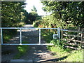
Start of footpath to shore
The photograph was taken from alongside the main road (the A814).
The footpath shown here (see Image) leads from this gate to the shore of the Clyde. At the far end of the path, it is necessary to pass through a cramped railway underpass (Image).
Image: © Lairich Rig
Taken: 22 Aug 2008
0.04 miles
2
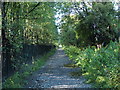
Footpath to shore
See Image
The path is perhaps called Dog's Loan; Dog's Loan Pumping Station is at its southern end.
Hunter's Burn rises at a well which is located at the south-western side of the base of Dumbowie Hill (Image); although diverted beneath nearby areas of housing, the burn reappears above ground near this point, and follows the side of this footpath; at the end of the path, the burn flows underneath a railway underpass (Image) before emerging onto the beach (Image).
The OS Object Name Book (1890s), giving authority for the name's appearance on the map, describes the burn as "a small stream on the High Mains of Dumbuck. The name is not generally known, but the proprietor wishes it to be adopted. The name has its origins not from a person's name but [from] the sportsmen or Hunters". On High Mains of Dumbuck, see Image and Image
Image: © Lairich Rig
Taken: 22 Aug 2008
0.04 miles
3
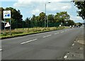
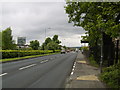
A814, Glasgow Road
At the Dumbarton boundary.
Image: © Richard Sutcliffe
Taken: 1 Sep 2023
0.06 miles
4
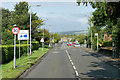
Welcome to Dumbarton
The start of Dumbarton, just past the Dumbuck House Hotel.
Image: © Stephen Sweeney
Taken: 11 May 2007
0.07 miles
5
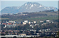
Dumbarton and Ben Lomond
The 3195ft (974m) high mountain dominates the backdrop in this telephoto view from Old Greenock Road to the west of Bishopton.
Image: © Thomas Nugent
Taken: 5 Apr 2015
0.07 miles
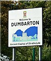
6
Welcome to Dumbarton
Eleven years earlier: Image
The sign ahead on the left is several decades old, and is one of several of the same kind that are or were situated at the edge of the town: "Welcome to Dumbarton, Ancient Capital of Strathclyde".
Image: © Lairich Rig
Taken: 9 Mar 2018
0.08 miles
7
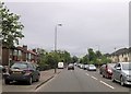
A814, Glasgow Road, Dumbarton
The A814 diverges from the A82 close to the Dumbuck Quarry near Milton. It heads west through Dumbuck, and the eastern suburbs of Dumbarton as Glasgow Road.
Image: © David Dixon
Taken: 26 Sep 2019
0.08 miles
8

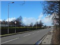
Glasgow Road
Looking east along the A814 towards Dumbuck.
Image: © Thomas Nugent
Taken: 27 Apr 2015
0.08 miles
9
Welcome to Dumbarton
Ancient Capital of Strathclyde. On the A814, Glasgow Road Image
Image: © Richard Sutcliffe
Taken: 1 Sep 2023
0.09 miles