IMAGES TAKEN NEAR TO
Strathleven Place, DUMBARTON, G82 1BA
Introduction
This page details the photographs taken nearby to Strathleven Place, G82 1BA by members of the Geograph project.
The Geograph project started in 2005 with the aim of publishing, organising and preserving representative images for every square kilometre of Great Britain, Ireland and the Isle of Man.

There are currently over 7.5m images from over14,400 individuals and you can help contribute to the project by visiting https://www.geograph.org.uk
Image Map
Images are licensed for reuse under creativecommons.org/licenses/by-sa/2.0
Notes
- Clicking on the map will re-center to the selected point.
- The higher the marker number, the further away the image location is from the centre of the postcode.
Image Listing (262 Images Found)
Images are licensed for reuse under creativecommons.org/licenses/by-sa/2.0
Image
Details
Distance
1
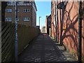
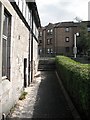
Path to Bonhill Road
This path, beside the buildings of Strathleven Place, is much used as a handy route between Bonhill Road and St James Retail Park. It crosses the line of Image, now mostly culverted, and Dumbarton Mill, a grain mill, was located close to the spot shown in the picture. See also Image, another site related to the mill.
Image: © Lairich Rig
Taken: 22 Mar 2020
0.01 miles
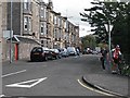
2
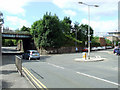
Bonhill Road
The signal box on the right is near Dumbarton Central station.
Image: © Thomas Nugent
Taken: 21 Aug 2010
0.04 miles
3
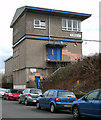
Dumbarton signal box
On Bankend Road, between Dumbarton East and Dumbarton Central stations.
Image: © Thomas Nugent
Taken: 18 Mar 2011
0.06 miles
4
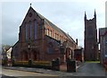
St Patrick's RC Church, Dumbarton
Construction of the main building took place from 1901—03; the design was by Dunn & Hansom, and it superseded one by Pugin & Pugin. The latter practice was, though, responsible for the detached tower on the right; it was built later, in the 1920s. A notice on the front of the church states that the parish was founded in 1830.
Image: © Lairich Rig
Taken: 19 Oct 2018
0.07 miles
5
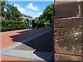
Bench mark on St Patrick's RC Church
I noticed this from the street in passing; see Image for the whole building in context. According to the OS database, this 3rd order cut mark is 5.438 metres above Newlyn datum; the end-note, by another contributor, explains these terms.
Image: © Lairich Rig
Taken: 5 Jun 2020
0.07 miles
6
Path between Bonhill Road and Meadow Road
Short cuts an acute junction. There is a shop by the steps on Bonhill Road.
Image: © Richard Webb
Taken: 1 Sep 2009
0.07 miles
7
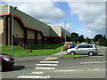
The Meadow Centre
Sports centre near Dumbarton Central station.
Image: © Thomas Nugent
Taken: 21 Aug 2010
0.08 miles
8
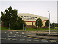
The Meadow Centre
Sports and leisure complex in Dumbarton.
Image: © Stephen Sweeney
Taken: 23 Aug 2007
0.09 miles
9

The Meadow Centre
A sports centre in a park near Dumbarton Central station.
Image: © Thomas Nugent
Taken: 21 Aug 2010
0.09 miles
10
Crosslet Road
Home of Dumbarton Academy. The road is used by National Cycle Route 7
Image: © Richard Webb
Taken: 1 Sep 2009
0.09 miles