IMAGES TAKEN NEAR TO
Cronin Street, DUMBARTON, G82 1AR
Introduction
This page details the photographs taken nearby to Cronin Street, G82 1AR by members of the Geograph project.
The Geograph project started in 2005 with the aim of publishing, organising and preserving representative images for every square kilometre of Great Britain, Ireland and the Isle of Man.

There are currently over 7.5m images from over14,400 individuals and you can help contribute to the project by visiting https://www.geograph.org.uk
Image Map
Images are licensed for reuse under creativecommons.org/licenses/by-sa/2.0
Notes
- Clicking on the map will re-center to the selected point.
- The higher the marker number, the further away the image location is from the centre of the postcode.
Image Listing (448 Images Found)
Images are licensed for reuse under creativecommons.org/licenses/by-sa/2.0
Image
Details
Distance
1
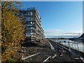
Construction on former distillery site
Image: © Lairich Rig
Taken: 28 Dec 2018
0.01 miles
2
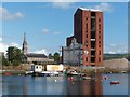
Remains of Ballantine's Distillery
This seven-storey brick tower, standing between Castle Street (Image) and the River Leven (Image), is all that remains of the former Ballantine's Distillery (which was built in the late 1930s; it was once Europe's biggest distillery). The site which it occupied had previously been the site of McMillan's Shipyard.
The mound to the right of the tower is evidence of development now taking place on this site (it later stalled: compare Image, a similar but wider picture taken about seven years later).
The nearby Image can be seen in the left-hand side of the photograph (early in the twentieth century, the proprietors of McMillan's Shipyard were given permission to expand into ground, on the south side of the parish church, that had formerly been a part of the kirkyard; see http://www.geograph.org.uk/article/Dumbarton-Cemetery#reduction-in-size for further details).
For an older view, which includes parts of the distillery that have now been demolished, see Image
A short section of a railway track that originally provided a rail connection to McMillan's Shipyard, and which later served the distillery that was built in its place, can still be seen: Image
According to "The Ballantine's Story" (Jonathan Mantle, 1991), the construction of the distillery on this site required 2 million bricks (red Accrington), 10,000 cubic yards of reinforced concrete, and 3,000 tons of steel. The complex included a small malt distillery called Inverleven, as well as warehouses and a bottling and blending plant. Preparations for war were given priority over construction on this site, delaying the completion of the building work.
Image: © Lairich Rig
Taken: 7 Aug 2009
0.02 miles
3
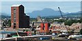
Remains of Ballantine's Distillery
A year earlier, many more of the buildings remained: Image The large brick tower (Image) was the last to go, finally being demolished almost 12 years after the present picture was taken; see Image and related images.
Ben Lomond (Image) dominates the skyline. The buildings in the foreground, on the near side of the River Leven, are on Sandpoint.
The tower near the centre of the picture is that of Image Much further away, visible in the gap between the Old Burgh Hall and the large brick tower, is the top of Image
The view is from Image; compare the equivalent view from there in 2013: Image
Image: © Lairich Rig
Taken: 8 Aug 2005
0.02 miles
4
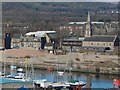
Former site of Ballantine's Distillery
Click on the end-note title for related pictures. The present view is from the White Tower Crag of Dumbarton Rock.
The former location of the tall brick tower, which had until recently been the last remnant of the distillery, is just below the centre of the picture, where a darker brown heap can be seen among the generally pale material on the site.
Just behind the site, Image is visible on the right, and part of Image on the left.
The River Leven is in the foreground; along the bottom edge of the picture are boats and buildings at Image
Image: © Lairich Rig
Taken: 26 Mar 2017
0.02 miles
5
Construction on former distillery site
The view is from the eastern end of a riverside path. The northern flank of Dumbarton Rock can be seen at the far right.
Image: © Lairich Rig
Taken: 15 Nov 2019
0.02 miles
6
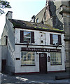
Elephant & Castle
Derelict pub on High Street, near Riverside Parish Church.
Image: © Thomas Nugent
Taken: 21 Aug 2010
0.03 miles
7

Construction on the former distillery site
Compare Image, an equivalent view from a year and half earlier. The present picture shows new structures taking shape here.
Image: © Lairich Rig
Taken: 10 Aug 2018
0.03 miles
8
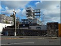
Construction on the former distillery site
The view is as in Image, but about two months later.
Image: © Lairich Rig
Taken: 6 Oct 2018
0.03 miles
9
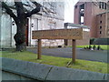
Sign at Dumbarton Riverside Parish Church
In the church grounds.
Image: © Stephen Sweeney
Taken: 25 Nov 2007
0.03 miles
10
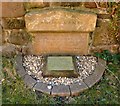
Gravestone of Captain James Lang
For context, see Image The stone is not visible in that picture, but it is one of several that are set against the southern boundary wall of the kirkyard, beside the path of stones that is shown in that photograph.
The lower half of this gravestone is buried (as is true of the other stones on the southern boundary wall), but its inscription is as follows:
"Agnes Lang, in memory of her husband, Captain James Lang, who died 15th June 1850, aged 45 years; also their daughter Marion Houston, who died 22nd January 1842 aged 2 years and 3 months."
James Lang was one of the Langs of Chapelton (also mentioned in Image). He was born in Dumbarton in 1805, and was educated there. James became a law clerk in the Town Clerk's office, but he later served on the town's steamers. In 1830, he became the captain of one of the Dumbarton Steamboat Company's vessels. He commanded, in succession, the "Dumbarton", the "Leven", the "Prince Albert", the "Lochlomond", and the "Queen". In 1835, he married Agnes MacCallum of Greenock; she was the daughter of Peter MacCallum, founder of P MacCallum & Sons, iron and steel merchants, Greenock.
(James Lang is also commemorated by a memorial in Greenock Cemetery: Image The above-mentioned Peter and Agnes MacCallum are listed there.)
As captain, James Lang used to communicate with his engineer using a worked-out system of knocks, banging the heel of his boot against the wooden cover of the steeple engine. It was at Captain Lang's recommendation that the firm of Denny Bros built a better method of communication into their vessel "Lochlomond", in the form of a mechanical indicator.
James Lang was a partner of the Dumbarton Steamboat Company. Contemporary accounts show that he was irreproachable in character, a man of good morals. He died at Castleroad House in 1850.
His son John went on to head the above-mentioned Greenock firm of P MacCallum & Sons, and he became prominent in Greenock's civic life, attaining the positions of Burgh Treasurer and Second Magistrate.
Reference: Donald MacLeod, "The God's Acres of Dumbarton" (1888), pages 230 to 232.
Image: © Lairich Rig
Taken: 21 Feb 2013
0.03 miles