Remains of Ballantine's Distillery
Introduction
The photograph on this page of Remains of Ballantine's Distillery by Lairich Rig as part of the Geograph project.
The Geograph project started in 2005 with the aim of publishing, organising and preserving representative images for every square kilometre of Great Britain, Ireland and the Isle of Man.

There are currently over 7.5m images from over 14,400 individuals and you can help contribute to the project by visiting https://www.geograph.org.uk
Remains of Ballantine's Distillery
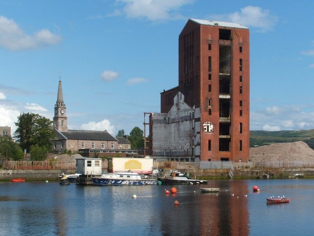
Image: © Lairich Rig Taken: 7 Aug 2009
This seven-storey brick tower, standing between Castle Street (Image) and the River Leven (Image), is all that remains of the former Ballantine's Distillery (which was built in the late 1930s; it was once Europe's biggest distillery). The site which it occupied had previously been the site of McMillan's Shipyard. The mound to the right of the tower is evidence of development now taking place on this site (it later stalled: compare Image, a similar but wider picture taken about seven years later). The nearby Image can be seen in the left-hand side of the photograph (early in the twentieth century, the proprietors of McMillan's Shipyard were given permission to expand into ground, on the south side of the parish church, that had formerly been a part of the kirkyard; see http://www.geograph.org.uk/article/Dumbarton-Cemetery#reduction-in-size for further details). For an older view, which includes parts of the distillery that have now been demolished, see Image A short section of a railway track that originally provided a rail connection to McMillan's Shipyard, and which later served the distillery that was built in its place, can still be seen: Image According to "The Ballantine's Story" (Jonathan Mantle, 1991), the construction of the distillery on this site required 2 million bricks (red Accrington), 10,000 cubic yards of reinforced concrete, and 3,000 tons of steel. The complex included a small malt distillery called Inverleven, as well as warehouses and a bottling and blending plant. Preparations for war were given priority over construction on this site, delaying the completion of the building work.
Images are licensed for reuse under creativecommons.org/licenses/by-sa/2.0
Image Location
Latitude
55.942325
Longitude
-4.567595