IMAGES TAKEN NEAR TO
Farm Road, CLYDEBANK, G81 6RS
Introduction
This page details the photographs taken nearby to Farm Road, G81 6RS by members of the Geograph project.
The Geograph project started in 2005 with the aim of publishing, organising and preserving representative images for every square kilometre of Great Britain, Ireland and the Isle of Man.

There are currently over 7.5m images from over14,400 individuals and you can help contribute to the project by visiting https://www.geograph.org.uk
Image Map
Images are licensed for reuse under creativecommons.org/licenses/by-sa/2.0
Notes
- Clicking on the map will re-center to the selected point.
- The higher the marker number, the further away the image location is from the centre of the postcode.
Image Listing (6 Images Found)
Images are licensed for reuse under creativecommons.org/licenses/by-sa/2.0
Image
Details
Distance
1
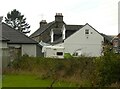
Duntiglennan Farm
This photograph was taken to try to replicate the first image for the square Image photographed and submitted in 2005.
Since that time a lot has changed. The white-coloured building has had dormer windows and a conservatory added, and new dwellings have been built alongside. The sign just outside reads 'Duntiglennan Farm and Steading'.
Image: © Richard Sutcliffe
Taken: 1 Oct 2021
0.01 miles
2
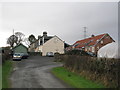
Duntiglennan Farm
Farm just north of Duntocher.
Image: © G Laird
Taken: 29 Dec 2013
0.01 miles
3
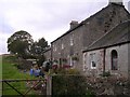
Duntiglennan Farm
Up the hill above Duntocher
Image: © Chris Upson
Taken: 14 Oct 2005
0.03 miles
4
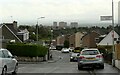
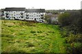
Looking down Farm Road
The tower blocks in the distance are at Radnor Park Image
Image: © Richard Sutcliffe
Taken: 1 Oct 2021
0.17 miles
5
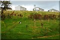
Grassy area beside Craigielea Road
A cat surveys its territory. The houses in the distance are on Mirren Drive.
Image: © Richard Sutcliffe
Taken: 11 Oct 2019
0.23 miles