IMAGES TAKEN NEAR TO
Roman Court, CLYDEBANK, G81 6BU
Introduction
This page details the photographs taken nearby to Roman Court, G81 6BU by members of the Geograph project.
The Geograph project started in 2005 with the aim of publishing, organising and preserving representative images for every square kilometre of Great Britain, Ireland and the Isle of Man.

There are currently over 7.5m images from over14,400 individuals and you can help contribute to the project by visiting https://www.geograph.org.uk
Image Map
Images are licensed for reuse under creativecommons.org/licenses/by-sa/2.0
Notes
- Clicking on the map will re-center to the selected point.
- The higher the marker number, the further away the image location is from the centre of the postcode.
Image Listing (81 Images Found)
Images are licensed for reuse under creativecommons.org/licenses/by-sa/2.0
Image
Details
Distance
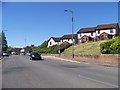
1
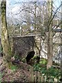
Roman Road bridge
Crosses the Duntocher Burn by Goldenhill Park.
Image: © Stephen Sweeney
Taken: 5 Apr 2009
0.02 miles
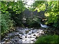
2
Crossing Scotland's oldest bridge?
Possibly. The bridge over Duntocher Burn at Roman Road.
Image: © Stephen Sweeney
Taken: 24 Jul 2008
0.03 miles
3
Roman Road bridge
One of Scotland's oldest bridges - some argue the oldest - crosses the Duntocher Burn.
Image: © Stephen Sweeney
Taken: 24 Jul 2008
0.04 miles
4
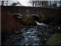
Scotland's oldest bridge?
The Roman Road bridge over the Duntocher Burn is argued to be the oldest bridge in Scotland. However, years of repairs and enhancements make dating the bridge an impossibility, and so this claim is likely to forever remain in dispute.
Image: © Stephen Sweeney
Taken: 9 Apr 2008
0.04 miles
6
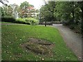
Millstones in Goldenhill Park
The two millstones that can be seen in the foreground are from Duntocher Corn Mill, which ceased operating in 1820.
The leaflet "Duntocher, Hardgate and Faifley Heritage Trail" points out that "the first reference to a corn mill in Duntocher is in the Paisley Abbey rental book of 1460 which notes that the Duntocher Burn was used by a mill owned by Thome de Strabrock".
The millstones are located near the north-western entrance of Goldenhill Park (that entrance can be seen in the background). Visible through the gate is a bridge which stands on the site of a Roman original: Image The cross on the left is part of a war memorial: http://www.geograph.org.uk/photo/68632
For another view, see Image, which includes another site of interest in the background: Image
Image: © Lairich Rig
Taken: 18 Sep 2009
0.04 miles
7
Millstones in Goldenhill Park
For the main description, see Image
The fenced-off area in the background contains an exposed section of the base of the Antonine Wall: http://www.geograph.org.uk/photo/1511463
Image: © Lairich Rig
Taken: 18 Sep 2009
0.05 miles
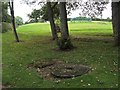
8
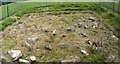
Exposed stone base of the Antonine Wall
The Antonine Wall was, for most of its length, a turf rampart built upon a stone base. A section of the base of the wall is exposed here in Goldenhill Park. The site is fenced off (the photo was taken through the railings), and is located not far from the north-western entrance of the park.
For a view of this site in context, see Image
At the top of the same slope is the location of a Roman fort: Image
Further east on the course of the Antonine Wall, another section of the stone base of the wall is exposed to view in Roman Park, Bearsden: Image A little further east again, two more sections are on display in New Kilpatrick Cemetery (also in Bearsden): Image and Image
Image: © Lairich Rig
Taken: 18 Sep 2009
0.05 miles
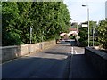
9
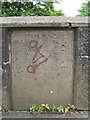
Inscription on Roman Bridge
Roman Bridge is really a name rather than an accurate description; an inscription on it makes clear that Lord Blantyre rebuilt it in 1772, and that it was rebuilt again in 1943, following damage sustained in the Clydebank Blitz of 1941.
See https://canmore.org.uk/site/43328/clydebank-duntocher (at Canmore); the first paragraph is discussing the pre-1941 bridge.
This inscription shown in this photograph appears on the west parapet of the Roman Bridge; for a view of the bridge itself, see: Image The Antonine Wall crossed the river at this point, so it is certain that there has been a bridge near here from at least the second century AD, when the Wall was built.
The inscription is written in imitation of the style of a Roman distance slab, but is, of course, more recent:
PONTEM.HUNC.EXT-
RUI.CURAVIT.IMP.T.
ÆL.ANTONIN.HA[D]R.
AUG.P.P.QUINT.LOLL.
URBIC.LEG.FERE.COL-
LAPSUM.RESTITUIT.
DOMINUS.DE.BLANT-
IRE.A.ÆR.CHR.
MDCCLXXII.
BLITZED 1941
REPAIRED 1943
Aside from the self-explanatory final two lines, the meaning is as follows (the translation is my own):
"For the Emperor Titus Aelius Antoninus Hadrianus Augustus, Father of his Country, the legate Quintus Lollius Urbicus arranged for this bridge to be built. It was restored from its ruined state by Lord Blantyre in the year 1772 AD".
[The expression "A.ÆR.CHR." feels out of place in an inscription that is otherwise in the style of a Roman distance slab. It is Late Latin, and literally means "of the Christian era", and is equivalent to "in the year of our Lord" or, more simply, "AD".]
This emperor is the Antoninus Pius of "Antonine Wall" fame (see the nearby Image); he appointed Quintus Lollius Urbicus as Governor of Roman Britain in about 138.
Image: © Lairich Rig
Taken: 22 Jun 2007
0.05 miles
10
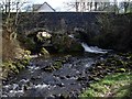
Roman Road bridge in Duntocher
A good unobstructed view of the bridge, thanks to the bare trees.
Image: © Stephen Sweeney
Taken: 5 Apr 2009
0.05 miles