IMAGES TAKEN NEAR TO
Antonine Gardens, CLYDEBANK, G81 6BQ
Introduction
This page details the photographs taken nearby to Antonine Gardens, G81 6BQ by members of the Geograph project.
The Geograph project started in 2005 with the aim of publishing, organising and preserving representative images for every square kilometre of Great Britain, Ireland and the Isle of Man.

There are currently over 7.5m images from over14,400 individuals and you can help contribute to the project by visiting https://www.geograph.org.uk
Image Map
Images are licensed for reuse under creativecommons.org/licenses/by-sa/2.0
Notes
- Clicking on the map will re-center to the selected point.
- The higher the marker number, the further away the image location is from the centre of the postcode.
Image Listing (69 Images Found)
Images are licensed for reuse under creativecommons.org/licenses/by-sa/2.0
Image
Details
Distance
1
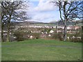
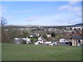
Duntocher and the Kilpatrick Hills
From Goldenhill Park.
Image: © Stephen Sweeney
Taken: 5 Apr 2009
0.02 miles
2
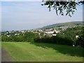
Duntocher from Goldenhill Park
Looking northwest.
Image: © Stephen Sweeney
Taken: 24 Jul 2008
0.06 miles
3
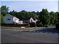
Antonine Gardens, Duntocher
New estate just off Beeches Road.
Image: © Stephen Sweeney
Taken: 24 Jul 2008
0.07 miles
4
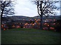
View back to Duntocher from Goldenhill Park
Image: © Stephen Sweeney
Taken: 9 Apr 2008
0.07 miles
5
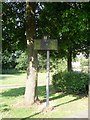
Sign at site of Roman influence
Duntocher was part of the route of the Antonine Wall, and on this site a Roman fort once stood.
Image: © Stephen Sweeney
Taken: 24 Jul 2008
0.07 miles
6

O'Donnells and the Glenhead Tavern
Two pubs side by side in Duntocher - a village of many pubs.
Image: © Stephen Sweeney
Taken: 9 Apr 2008
0.08 miles
7
Duntocher from Goldenhill
Near to the trig point.
Image: © Stephen Sweeney
Taken: 5 Apr 2009
0.08 miles
8
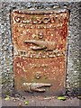
Old milestone in Duntocher
The milestone stands on the southern side of Image
It is recorded on the first-edition OS map (surveyed in 1861), and bears two index hands, and the text "Glasgow Royal Exchange 9 / Dumbarton Cross 6½".
Image: © Lairich Rig
Taken: 18 Oct 2005
0.08 miles
9
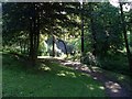
Woodland path by Duntocher Burn
Beautifully lit by the morning sun.
Image: © Stephen Sweeney
Taken: 24 Jul 2008
0.09 miles
10
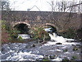
Small waterfalls on the Duntocher Burn
The bridge in the background carries Roman Road south from Duntocher.
Image: © G Laird
Taken: 29 Dec 2013
0.09 miles