IMAGES TAKEN NEAR TO
Cochno Brae, CLYDEBANK, G81 6BP
Introduction
This page details the photographs taken nearby to Cochno Brae, G81 6BP by members of the Geograph project.
The Geograph project started in 2005 with the aim of publishing, organising and preserving representative images for every square kilometre of Great Britain, Ireland and the Isle of Man.

There are currently over 7.5m images from over14,400 individuals and you can help contribute to the project by visiting https://www.geograph.org.uk
Image Map
Images are licensed for reuse under creativecommons.org/licenses/by-sa/2.0
Notes
- Clicking on the map will re-center to the selected point.
- The higher the marker number, the further away the image location is from the centre of the postcode.
Image Listing (40 Images Found)
Images are licensed for reuse under creativecommons.org/licenses/by-sa/2.0
Image
Details
Distance
1
Cochno Brae housing development
New detached houses off Cochno Road.
Image: © Stephen Sweeney
Taken: 8 Feb 2008
0.02 miles
2
Cochno Brae from Cochno Road
New housing development on the outskirts of Clydebank.
Image: © Stephen Sweeney
Taken: 20 Jun 2008
0.03 miles
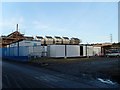
3

Site office for Cochno Brae housing development
New housing area built just off Cochno Road.
Image: © Stephen Sweeney
Taken: 8 Feb 2008
0.03 miles
4
Cochno Road
Cochno Road looking south east to the scheme of Faifley!
Image: © billy campbell
Taken: 20 Sep 2006
0.03 miles

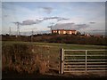
6

Cochno Brae
New development in Clydebank. Old housing in Faifley can be seen at the end of the street.
Image: © Stephen Sweeney
Taken: 8 Feb 2008
0.04 miles
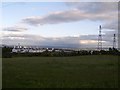
7

Faifley from Cochno Road
Looking to Clydebank's northernmost housing area from Cochno Road.
Image: © Stephen Sweeney
Taken: 8 Feb 2008
0.08 miles
9
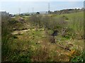
The Cochno Burn
At the tree-lined bend in its course, the Cochno Burn is joined by another burn, as shown in Image; see the map.
One of the details in the background is the Image
Image: © Lairich Rig
Taken: 21 Apr 2014
0.08 miles
10
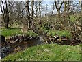
The Cochno Burn
The Cochno Burn flows in at the right, and out on the left. It is joined here by another burn, which is unnamed on the map, but which originates in an area to the north of this spot.
For more context, see Image, taken from high on a neighbouring slope.
Image: © Lairich Rig
Taken: 21 Apr 2014
0.08 miles