IMAGES TAKEN NEAR TO
Orbiston Place, CLYDEBANK, G81 5DN
Introduction
This page details the photographs taken nearby to Orbiston Place, G81 5DN by members of the Geograph project.
The Geograph project started in 2005 with the aim of publishing, organising and preserving representative images for every square kilometre of Great Britain, Ireland and the Isle of Man.

There are currently over 7.5m images from over14,400 individuals and you can help contribute to the project by visiting https://www.geograph.org.uk
Image Map
Images are licensed for reuse under creativecommons.org/licenses/by-sa/2.0
Notes
- Clicking on the map will re-center to the selected point.
- The higher the marker number, the further away the image location is from the centre of the postcode.
Image Listing (41 Images Found)
Images are licensed for reuse under creativecommons.org/licenses/by-sa/2.0
Image
Details
Distance
1
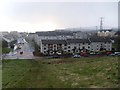
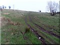
Faifley from Douglas Muir climb
Looking to Faifley Road and Douglas Muir Road.
Image: © Stephen Sweeney
Taken: 12 Apr 2008
0.04 miles
2
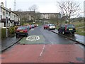
A very wet Douglas Muir Road
It was bright sunshine when I left the house!
Image: © Stephen Sweeney
Taken: 12 Apr 2008
0.05 miles
3
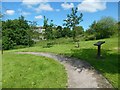
Douglas Muir Wildlife Trail
The path is on the east side of Image, near the corner of Faifley Road.
The artwork on the information panels beside the path (one of them is shown in Image) was designed by pupils from local primary schools (Edinbarnet and St Joseph's).
See Image for a view from further back on the path.
Image: © Lairich Rig
Taken: 15 Jul 2015
0.06 miles
4

Douglas Muir Wildlife Trail
The path is on the east side of Image, near the corner of Faifley Road.
The artwork on the information panels beside the path (one of them is shown in Image) was designed by pupils from local primary schools (Edinbarnet and St Joseph's).
See Image for a view from a little further along the path.
Image: © Lairich Rig
Taken: 15 Jul 2015
0.06 miles
5

Sign at Douglas Muir Wildlife Trail
With information on the various species worth spotting in the area.
Image: © Stephen Sweeney
Taken: 12 Apr 2008
0.08 miles
6
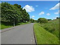
Douglas Muir Road
This section of the road is part of the Clyde Coastal Path. The road ends not far ahead (Image), but a path continues from there to Cochno Road.
Nearby, on the east side of the road, is the Image
Image: © Lairich Rig
Taken: 15 Jul 2015
0.09 miles
8
The northern end of Douglas Muir Road
The Clyde Coastal Path, a core path, follows Image to its northern end, shown here, and continues on the same line, as a made path, whose beginning can be seen ahead: Image
Field Road branches off to the left here.
Image: © Lairich Rig
Taken: 15 Jul 2015
0.11 miles
9
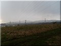
Following pylons back to Kilpatrick Hills
From Douglas Muir, on a typically wet day.
Image: © Stephen Sweeney
Taken: 12 Apr 2008
0.12 miles
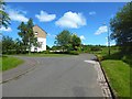
10
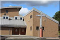
St Joseph's R.C. Church, Faifley
Opened 1997. Designed by Jacobsen & French.
Image: © Leslie Barrie
Taken: 23 Aug 2014
0.12 miles