IMAGES TAKEN NEAR TO
Craighaw Street, CLYDEBANK, G81 5BU
Introduction
This page details the photographs taken nearby to Craighaw Street, G81 5BU by members of the Geograph project.
The Geograph project started in 2005 with the aim of publishing, organising and preserving representative images for every square kilometre of Great Britain, Ireland and the Isle of Man.

There are currently over 7.5m images from over14,400 individuals and you can help contribute to the project by visiting https://www.geograph.org.uk
Image Map (Loading...)


Getting Data...Please wait
Leaflet Map data © OpenStreetMap
Images are licensed for reuse under creativecommons.org/licenses/by-sa/2.0
Notes
- Clicking on the map will re-center to the selected point.
- The higher the marker number, the further away the image location is from the centre of the postcode.
Image Listing (37 Images Found)
Images are licensed for reuse under creativecommons.org/licenses/by-sa/2.0
Image
Details
Distance
1
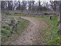
Footpath at Auchnacrag
Takes you around the Auchnacrag area, or leads back to Faifley.
Image: © Stephen Sweeney
Taken: 20 Mar 2007
0.10 miles
2
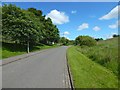
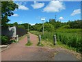
Douglas Muir Road
This section of the road is part of the Clyde Coastal Path. The road ends not far ahead (Image), but a path continues from there to Cochno Road.
Nearby, on the east side of the road, is the Image
Image: © Lairich Rig
Taken: 15 Jul 2015
0.12 miles
3
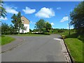
The northern end of Douglas Muir Road
The Clyde Coastal Path, a core path, follows Image to its northern end, shown here, and continues on the same line, as a made path, whose beginning can be seen ahead: Image
Field Road branches off to the left here.
Image: © Lairich Rig
Taken: 15 Jul 2015
0.12 miles
4
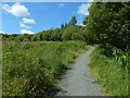
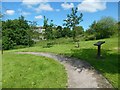
Path to Auchnacraig Urban Park
The picture was taken from near the start of the path, which branches off from the one shown in Image (as is mentioned there).
Image: © Lairich Rig
Taken: 15 Jul 2015
0.13 miles
5
Start of a path to Cochno Road
The pictures shows the point where the path begins at Image
For a view from a little further along the main path, showing the start of a boardwalk that leads over a burn, see Image
Not far beyond the point from which the present picture was taken, another path branches off to the left (west): Image
Image: © Lairich Rig
Taken: 15 Jul 2015
0.13 miles
6
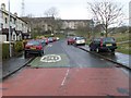
A very wet Douglas Muir Road
It was bright sunshine when I left the house!
Image: © Stephen Sweeney
Taken: 12 Apr 2008
0.13 miles
7
Douglas Muir Wildlife Trail
The path is on the east side of Image, near the corner of Faifley Road.
The artwork on the information panels beside the path (one of them is shown in Image) was designed by pupils from local primary schools (Edinbarnet and St Joseph's).
See Image for a view from further back on the path.
Image: © Lairich Rig
Taken: 15 Jul 2015
0.14 miles
8
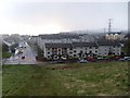
Faifley from Douglas Muir climb
Looking to Faifley Road and Douglas Muir Road.
Image: © Stephen Sweeney
Taken: 12 Apr 2008
0.14 miles
9

Path to Cochno Road
This is a view from further along the path that is shown in Image
The boardwalk leads over a burn: Image The path and the burn are marked on the 1:25000 map.
For a view from further ahead, see Image
Image: © Lairich Rig
Taken: 15 Jul 2015
0.14 miles
10
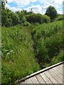
Burn seen from boardwalk
The burn is shown flowing away from the photographer's position. The boardwalk from which the picture was taken is shown in context in Image
A considerable distance downstream from here, this burn feeds into the Cochno Burn. The burn and the path of which the boardwalk is a part are both depicted on the 1:25000 map.
Image: © Lairich Rig
Taken: 15 Jul 2015
0.14 miles