IMAGES TAKEN NEAR TO
Janetta Street, CLYDEBANK, G81 3EJ
Introduction
This page details the photographs taken nearby to Janetta Street, G81 3EJ by members of the Geograph project.
The Geograph project started in 2005 with the aim of publishing, organising and preserving representative images for every square kilometre of Great Britain, Ireland and the Isle of Man.

There are currently over 7.5m images from over14,400 individuals and you can help contribute to the project by visiting https://www.geograph.org.uk
Image Map
Images are licensed for reuse under creativecommons.org/licenses/by-sa/2.0
Notes
- Clicking on the map will re-center to the selected point.
- The higher the marker number, the further away the image location is from the centre of the postcode.
Image Listing (42 Images Found)
Images are licensed for reuse under creativecommons.org/licenses/by-sa/2.0
Image
Details
Distance
1
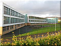
Clydebank High School
On Janetta Street, Clydebank High School is a non-denominational high school in Clydebank.
Image: © G Laird
Taken: 29 Dec 2013
0.01 miles
2
Clydebank High School
Seen from Boquhanran Park.
Image: © Richard Sutcliffe
Taken: 29 Apr 2021
0.05 miles
3
Clydebank High School from Green Street
Built as a replacement for Clydebank School on Kilbowie Road, which was destroyed in the Clydebank Blitz. The decision to replace the school with this one was actually taken before the war, and construction of Clydebank High School began in the mid-1930s. Because of the war, the school did not open until 1947.
Image: © Stephen Sweeney
Taken: 30 Mar 2008
0.05 miles
4
Looking to Radnor Park, Clydebank
From the roundabout on Second Avenue.
Image: © Stephen Sweeney
Taken: 30 Dec 2007
0.08 miles
5
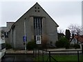
Radnor Park Congregational Church
This church was built in 1961 as a replacement for one of the same name which was damaged in the Clydebank Blitz of 1941.
Image: © Stephen Sweeney
Taken: 30 Mar 2008
0.08 miles
6
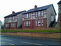
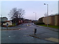
Second Avenue housing
There is such a variation in housing quality on Second Avenue - this is more the upper end of the market.
Image: © Stephen Sweeney
Taken: 30 Dec 2007
0.10 miles
7
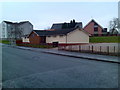
Barns o' Clyde Lodge, Clydebank
The name Barns o' Clyde was the original name of the farming area that would become the town of Clydebank.
Image: © Stephen Sweeney
Taken: 30 Dec 2007
0.10 miles
8
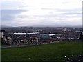
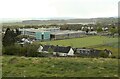
New Clydebank High School and Radnor Park and Parkhall areas
From atop Kilbowie Hill in Clydebank.
Image: © Stephen Sweeney
Taken: 25 Mar 2009
0.10 miles
9
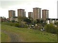
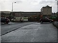
Tower blocks, Radnor Park
Seen from Boquhanran Park.
Image: © Richard Sutcliffe
Taken: 29 Apr 2021
0.14 miles
10
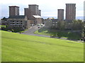
Radnor Park Tower Blocks
Tower blocks viewed from Radnor Park
Image: © Chris Upson
Taken: 14 Oct 2005
0.14 miles