IMAGES TAKEN NEAR TO
Melfort Gardens, CLYDEBANK, G81 2HG
Introduction
This page details the photographs taken nearby to Melfort Gardens, G81 2HG by members of the Geograph project.
The Geograph project started in 2005 with the aim of publishing, organising and preserving representative images for every square kilometre of Great Britain, Ireland and the Isle of Man.

There are currently over 7.5m images from over14,400 individuals and you can help contribute to the project by visiting https://www.geograph.org.uk
Image Map
Images are licensed for reuse under creativecommons.org/licenses/by-sa/2.0
Notes
- Clicking on the map will re-center to the selected point.
- The higher the marker number, the further away the image location is from the centre of the postcode.
Image Listing (59 Images Found)
Images are licensed for reuse under creativecommons.org/licenses/by-sa/2.0
Image
Details
Distance
1
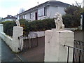
Interesting gate design on Drumry Road
Perhaps the lions act as guard dogs?! I liked it anyway.
Image: © Stephen Sweeney
Taken: 8 Nov 2007
0.07 miles
2
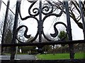
Looking into Drumry cemetery
Peering through the gates.
Image: © Stephen Sweeney
Taken: 24 Jan 2008
0.07 miles
3

Entrance to Drumry cemetery
From Montrose Street.
Image: © Stephen Sweeney
Taken: 24 Jan 2008
0.07 miles
4

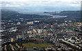
Drumry from the air
Clydebank police station is in the foreground. The Erskine Bridge and Firth of Clyde are in the distance. Dumbarton and Dumbarton Rock are in the right distance, Inverclyde on the left.
Image: © Thomas Nugent
Taken: 7 Apr 2016
0.08 miles
5
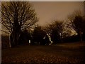
Drumry cemetery at night
A graveyard - not a chilling place to be at night.....!
Image: © Stephen Sweeney
Taken: 24 Jan 2008
0.08 miles

7
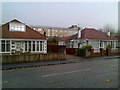
Array of houses in Drumry
From council and ex-council build on Robert Burns Avenue, to slick bungalows on Drumry Road.
Image: © Stephen Sweeney
Taken: 8 Nov 2007
0.09 miles
8
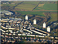
Drumry from the air
Queen Mary Avenue is in the foreground, Kilbowie Cemetery is in the left foreground. The Erskine Bridge, Firth of Clyde and the Cowal Hills can all be seen.
Image: © Thomas Nugent
Taken: 7 Apr 2016
0.09 miles
9

Wall by Drumry Cemetery
Separates the Cemetery from Montrose Street.
Image: © Stephen Sweeney
Taken: 6 May 2008
0.09 miles
10
Clydebank from the air
The towerblocks are at Kirkoswald Drive, alongside the A82 Great Western Road.
Image: © Thomas Nugent
Taken: 4 Dec 2016
0.10 miles