IMAGES TAKEN NEAR TO
Jean Armour Drive, CLYDEBANK, G81 2EX
Introduction
This page details the photographs taken nearby to Jean Armour Drive, G81 2EX by members of the Geograph project.
The Geograph project started in 2005 with the aim of publishing, organising and preserving representative images for every square kilometre of Great Britain, Ireland and the Isle of Man.

There are currently over 7.5m images from over14,400 individuals and you can help contribute to the project by visiting https://www.geograph.org.uk
Image Map
Images are licensed for reuse under creativecommons.org/licenses/by-sa/2.0
Notes
- Clicking on the map will re-center to the selected point.
- The higher the marker number, the further away the image location is from the centre of the postcode.
Image Listing (59 Images Found)
Images are licensed for reuse under creativecommons.org/licenses/by-sa/2.0
Image
Details
Distance
2
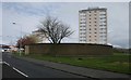
Garages off Kirkoswald Drive
The structure in the foreground is a block of garages for the use of local residents. There are three of these structures, each associated with a tower block. When seen from above the garage blocks are circular, with 18 individual garages in each, radiating like the spokes of a wheel around an open central area.
Garscadden View is the tower block in the background.
Image: © Richard Sutcliffe
Taken: 14 Apr 2017
0.04 miles
3
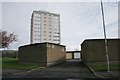
Garages off Kirkoswald Drive
The structure in the foreground is a block of garages for the use of local residents. There are three of these structures, each associated with a tower block. When seen from above the garage blocks are circular, with 18 individual garages in each, radiating like the spokes of a wheel around an open central area.
Garscadden View is the tower block in the background.
Image: © Richard Sutcliffe
Taken: 14 Apr 2017
0.04 miles
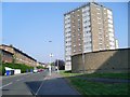
4
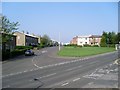
Flats, Kirkoswald Drive
View across the A82
Image: © Richard Webb
Taken: 4 Jan 2016
0.06 miles
5
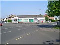
Shops in Drumry
Between Kirkoswald Drive and Riddell Street.
Image: © Stephen Sweeney
Taken: 8 May 2008
0.07 miles
6
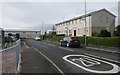
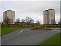
Tarbolton Drive
Looking from Riddell Street towards Jean Armour Drive.
Image: © Richard Sutcliffe
Taken: 14 Apr 2017
0.07 miles
7
Robert Burns Avenue from Kirkoswald Drive
In Drumry.
Image: © Stephen Sweeney
Taken: 8 May 2008
0.07 miles
8
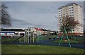
Play park off Kirkoswald Drive
The tower block is Dunscombe View.
Image: © Richard Sutcliffe
Taken: 14 Apr 2017
0.07 miles
9
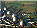
Clydebank from the air
The towerblocks are at Kirkoswald Drive, alongside the A82 Great Western Road. The golf driving range across Great Western Road can also be seen.
Image: © Thomas Nugent
Taken: 4 Dec 2016
0.09 miles
10
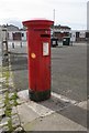
George VI pillar box, Kirkoswald Drive
Postbox number G81 1114D.
Image: © Richard Sutcliffe
Taken: 14 Apr 2017
0.10 miles