IMAGES TAKEN NEAR TO
Cable Depot Road, CLYDEBANK, G81 1UY
Introduction
This page details the photographs taken nearby to Cable Depot Road, G81 1UY by members of the Geograph project.
The Geograph project started in 2005 with the aim of publishing, organising and preserving representative images for every square kilometre of Great Britain, Ireland and the Isle of Man.

There are currently over 7.5m images from over14,400 individuals and you can help contribute to the project by visiting https://www.geograph.org.uk
Image Map
Images are licensed for reuse under creativecommons.org/licenses/by-sa/2.0
Notes
- Clicking on the map will re-center to the selected point.
- The higher the marker number, the further away the image location is from the centre of the postcode.
Image Listing (107 Images Found)
Images are licensed for reuse under creativecommons.org/licenses/by-sa/2.0
Image
Details
Distance
1

Express Electrical & Engineering Supplies, Ltd
Front
Image: © anna
Taken: 28 Aug 2023
0.03 miles
2
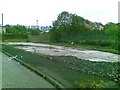
Demolished building, Cable Depot Road
Image: © Alex McGregor
Taken: 22 Jun 2011
0.04 miles
3

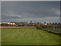
Promenade at Clydebank
Looking east towards the Titan crane.
Image: © M J Richardson
Taken: 24 Apr 2014
0.06 miles
4
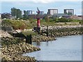
Dalmuir Light
This old beacon was photographed from a Image (it can be seen, although not very well, in the background of that image); see Image for another view. It is very similar in design to a beacon that stands at Old Kilpatrick; for that beacon, see Image and Image
See the last of those links for a reference to their purpose; as noted there, both of the lights date from the nineteenth century, and they mark the location of bends in the river. For more on those lights, see Image, which is also similar in design.
[An earlier map, c.1898, does show a "Dalmuir Light (fixed red)", but it was further downriver. However, that map does show another beacon, simply labelled "beacon", very close to the spot where the present Dalmuir Light is located; making allowance for refinements in positioning over the years, it may be the same spot.]
Originally (c.1914), the maps show Dalmuir Light as "flashing white"; by the 1960s, it is "flashing red", as at present. It is located on the north bank of the Clyde, between the former sites of two shipyards: Beardmore's, which was downriver, and John Brown's, which was upriver.
Image: © Lairich Rig
Taken: 10 Jun 2011
0.07 miles
5

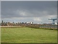
River Clyde
At Clydebank with view of the Titan Crane.
Image: © Billy McCrorie
Taken: 12 Nov 2015
0.07 miles
6
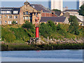
Dalmuir Light Beacon
Nineteenth century light marking a bend in the river. The photograph was taken from the Clydeside Community Park, using a telephoto lens.
Image: © David Dixon
Taken: 2 Aug 2019
0.07 miles
7

River Clyde and walkway at Dalmuir
Titan crane in the distance
Image: © John Ferguson
Taken: 19 Jan 2021
0.08 miles
8
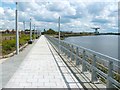
Walkway beside the River Clyde
The walkway is located near the Image
The Image (see also Image) can be seen in the background, on the right. Nearer, but harder to see, is an old beacon on the shore; it is just to the right of the upright pole that is on the right-hand side of the walkway. For a closer look, and for more information, see Image
Image: © Lairich Rig
Taken: 10 Jun 2011
0.08 miles
9
Looking east from Beardmore Hotel
To Clydebank Town Hall clock.
Image: © Stephen Sweeney
Taken: 30 Mar 2008
0.08 miles
10
View of Clydebank East from near Beardmore Hotel
Looking to Clydebank Town Hall, the Yoker flats and the Titan Crane.
Image: © Stephen Sweeney
Taken: 30 Mar 2008
0.09 miles