IMAGES TAKEN NEAR TO
Miller Street, CLYDEBANK, G81 1UP
Introduction
This page details the photographs taken nearby to Miller Street, G81 1UP by members of the Geograph project.
The Geograph project started in 2005 with the aim of publishing, organising and preserving representative images for every square kilometre of Great Britain, Ireland and the Isle of Man.

There are currently over 7.5m images from over14,400 individuals and you can help contribute to the project by visiting https://www.geograph.org.uk
Image Map
Images are licensed for reuse under creativecommons.org/licenses/by-sa/2.0
Notes
- Clicking on the map will re-center to the selected point.
- The higher the marker number, the further away the image location is from the centre of the postcode.
Image Listing (235 Images Found)
Images are licensed for reuse under creativecommons.org/licenses/by-sa/2.0
Image
Details
Distance
1
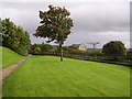
Clydebank Business Park Landscaped Gardens
A strip of landscaped gardens sandwiched between Clydebank Business Park and the Forth Clyde Canal, close to Kilbowie Road.
Image: © Chris Upson
Taken: 28 Sep 2005
0.03 miles
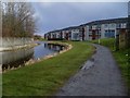
2
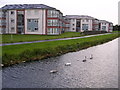
Swans on the Forth Clyde Canal
Swans glide past modern housing sandwiched between the canal and Dumbarton Road, just across from Clydebank Business Park.
Image: © Chris Upson
Taken: 28 Sep 2005
0.03 miles
3
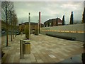
Solidarity Plaza, looking westward
Plaza commemorating the links between Polish and Scottish shipbuilding
Image: © Darrin Antrobus
Taken: 15 Mar 2005
0.03 miles
4
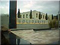
Solidarity Plaza
Commemorates the links between Polish and Scottish shipbuilding
Image: © Darrin Antrobus
Taken: 15 Mar 2005
0.03 miles
5
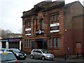
The Crow Bar, Clydebank
Recently-opened rock bar in Clydebank. Features live music, games nights and nothing but the best in rock music. The building has a date stone in its facade - it was constructed in 1924, which must make it one of the oldest buildings in Clydebank, as the town was only founded in 1886, and many of its buildings and structures were destroyed in the Clydebank Blitz of 13-14 March 1941.
Image: © Stephen Sweeney
Taken: 27 Jan 2008
0.04 miles
6
Miller Street housing development, Clydebank
This development dates back to about 2002. Very close to the canal.
Image: © Stephen Sweeney
Taken: 30 Mar 2008
0.04 miles
7

Clydebank Sea cadets facilities
The base for the Clydebank Sea cadets (TS Queen Elizabeth SCC Unit No.87) on Miller Street.
Image: © Richard Sutcliffe
Taken: 21 Jan 2022
0.04 miles
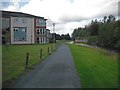
8
Forth & Clyde Canal
A quiet spot near Kilbowie Road bridge.
Image: © Thomas Nugent
Taken: 7 Aug 2010
0.05 miles
9

New houses under construction
On Miller Street and a former car park.
Image: © Richard Sutcliffe
Taken: 21 Jan 2022
0.05 miles
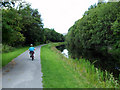
10
Forth and Clyde Canal
The widened towpath is now a cycle path (National Cycle Route 7) between Glasgow and Balloch. The new flats are off Millar Street. A ground floor flat (no. 41) was on the market at the time for a fixed price of £139,995.
Image: © Richard Webb
Taken: 1 Sep 2009
0.05 miles