IMAGES TAKEN NEAR TO
Alexander Street, CLYDEBANK, G81 1SQ
Introduction
This page details the photographs taken nearby to Alexander Street, G81 1SQ by members of the Geograph project.
The Geograph project started in 2005 with the aim of publishing, organising and preserving representative images for every square kilometre of Great Britain, Ireland and the Isle of Man.

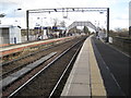
There are currently over 7.5m images from over14,400 individuals and you can help contribute to the project by visiting https://www.geograph.org.uk
Image Map
Images are licensed for reuse under creativecommons.org/licenses/by-sa/2.0
Notes
- Clicking on the map will re-center to the selected point.
- The higher the marker number, the further away the image location is from the centre of the postcode.
Image Listing (310 Images Found)
Images are licensed for reuse under creativecommons.org/licenses/by-sa/2.0
Image
Details
Distance
1
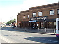
John Browns Pub
in Clydebank, near Clydebank station.
Image: © Darrin Antrobus
Taken: 8 May 2007
0.00 miles
2
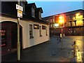
Chandlers bar
At the bottom of Kilbowie Road, Clydebank.
Image: © Stephen Sweeney
Taken: 14 Jan 2008
0.02 miles
3
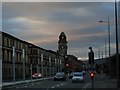
Glasgow Road, Clydebank
Looking to the Town Hall.
Image: © Stephen Sweeney
Taken: 17 Mar 2008
0.02 miles
4
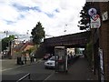
Railway bridge and steps leading to Clydebank station
The bridge is number 20 and crosses Alexander Street. The station was opened when the Glasgow, Yoker and Clydebank Railway was extended to Dalmuir. The station was then known as Clydebank Central; the original terminus of the line being renamed Clydebank East.
Image: © Tim Glover
Taken: 22 Jul 2011
0.03 miles
5
Clydebank railway station
Opened in 1897 by the North British Railway, this station was on the extension of the Glasgow Yoker and Clydebank Railway to Dalmuir.
Whilst it might have been expected that the original Clydebank East terminus station might have closed upon the opening of this through line, it actually remained in use until 1959.
View east towards Yoker and Glasgow.
Image: © Nigel Thompson
Taken: 15 Mar 2013
0.03 miles
6
Clydebank station, view west
View westward, towards Dalmuir, Helensburgh, Craigendoran, Arrochar and the West Highland Line: ex-NBR Glasgow Queen Street etc. and Airdrie etc. via Queen Street Low Level (North Suburban lines, electrified since 1960) to Helensburgh and West Highland Line. The station, 'Clydebank Central' until 14/6/65, was rebuilt at that time.
Image: © Ben Brooksbank
Taken: 30 Jun 1997
0.03 miles
7

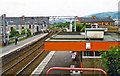
Clydebank station, view east
View SE, towards Glasgow etc.: ex-North British Helensburgh - Airdrie: North Suburban lines, electrified 1960 and subsequently used as well by Argyle Line services via Glasgow Central (Low Level); see also Image
Image: © Ben Brooksbank
Taken: 30 Jun 1997
0.03 miles
8
Kilbowie Road at Dumbarton Road
With a fine view to the Titan Crane.
Image: © Stephen Sweeney
Taken: 14 Jan 2008
0.04 miles
9
Railway bridge at Clydebank train station
At the bottom of Kilbowie Road.
Image: © Stephen Sweeney
Taken: 2 Dec 2007
0.04 miles
10
Glasgow Road and Titan Crane
From Hume Street.
Image: © Stephen Sweeney
Taken: 14 Jan 2008
0.05 miles