IMAGES TAKEN NEAR TO
Lochlibo Road, GLASGOW, G78 4DN
Introduction
This page details the photographs taken nearby to Lochlibo Road, G78 4DN by members of the Geograph project.
The Geograph project started in 2005 with the aim of publishing, organising and preserving representative images for every square kilometre of Great Britain, Ireland and the Isle of Man.

There are currently over 7.5m images from over14,400 individuals and you can help contribute to the project by visiting https://www.geograph.org.uk
Image Map
Images are licensed for reuse under creativecommons.org/licenses/by-sa/2.0
Notes
- Clicking on the map will re-center to the selected point.
- The higher the marker number, the further away the image location is from the centre of the postcode.
Image Listing (7 Images Found)
Images are licensed for reuse under creativecommons.org/licenses/by-sa/2.0
Image
Details
Distance
5
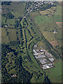
McLaren's Nursery from the air
Caldwell Golf Club is on the left, part of Uplawmoor is visible at the top.
Image: © Thomas Nugent
Taken: 19 Jul 2015
0.11 miles
6
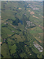
Loch Libo from the air
Caldwell golf course and McLaren's Nursery are visible in the lower right corner.
Image: © Thomas Nugent
Taken: 19 Jul 2015
0.20 miles
7
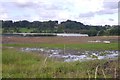
Levelled ground
A flat area cut out of a field. It was rather waterlogged, and is almost certainly the site of future expansion of the Caldwell nursery glasshouses.
Image: © Richard Webb
Taken: 9 Sep 2017
0.24 miles