IMAGES TAKEN NEAR TO
Uplawmoor, GLASGOW, G78 4BX
Introduction
This page details the photographs taken nearby to G78 4BX by members of the Geograph project.
The Geograph project started in 2005 with the aim of publishing, organising and preserving representative images for every square kilometre of Great Britain, Ireland and the Isle of Man.

There are currently over 7.5m images from over14,400 individuals and you can help contribute to the project by visiting https://www.geograph.org.uk
Image Map
Images are licensed for reuse under creativecommons.org/licenses/by-sa/2.0
Notes
- Clicking on the map will re-center to the selected point.
- The higher the marker number, the further away the image location is from the centre of the postcode.
Image Listing (9 Images Found)
Images are licensed for reuse under creativecommons.org/licenses/by-sa/2.0
Image
Details
Distance
1
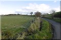
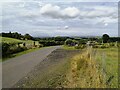
Road by Linnhead
One of a network of yellow roads between Neilston and Dunlop crossing hills of igneous rock. There has been a lot of recent wind turbine erection around here.
Image: © Richard Webb
Taken: 6 Nov 2016
0.08 miles
3
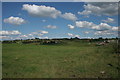
West Uplaw
Looking across fields towards West Uplaw. The edge of Linnhead can be seen on the right.
Image: © Richard Sutcliffe
Taken: 19 Jul 2016
0.14 miles
4
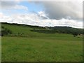
Tennoch Hill
Sheep grazing on the slopes of Tennoch Hill.
Image: © Chris Court
Taken: 12 Nov 2005
0.15 miles
5
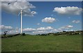
Wind turbine near Linnhead
A single turbine located to the north west of the farm.
Image: © Richard Sutcliffe
Taken: 19 Jul 2016
0.17 miles
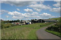
6
Road by Linnhead
The road crosses wet farmland here and not far above is an area of young trees.
Image: © Richard Webb
Taken: 6 Nov 2016
0.20 miles
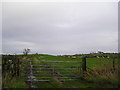
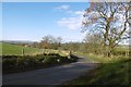
7
Gates at a bend in the road
This is on the minor road heading toward Uplawmoor just after Linnhead. The gate glimpsed end-on at the right of the picture is for the solitary wind turbine seen in Image
Image: © Alec MacKinnon
Taken: 12 Aug 2021
0.20 miles
8
East side of Tennoch Hill
Much steeper than south end of hill shown in another image for this square https://www.geograph.org.uk/photo/77099 , with gorse growing on steepest parts providing shelter for birds. Woods on skyline to right are on Caldwell Law.
Image: © Marion Boyle
Taken: 8 Jul 2008
0.22 miles
9
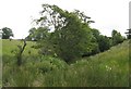
Deep gully below West Uplaw Farm
Contours showing this gully are evident on the Pathfinder scale map
Image: © Marion Boyle
Taken: 8 Jul 2008
0.23 miles