IMAGES TAKEN NEAR TO
Uplawmoor, GLASGOW, G78 4BL
Introduction
This page details the photographs taken nearby to G78 4BL by members of the Geograph project.
The Geograph project started in 2005 with the aim of publishing, organising and preserving representative images for every square kilometre of Great Britain, Ireland and the Isle of Man.

There are currently over 7.5m images from over14,400 individuals and you can help contribute to the project by visiting https://www.geograph.org.uk
Image Map
Images are licensed for reuse under creativecommons.org/licenses/by-sa/2.0
Notes
- Clicking on the map will re-center to the selected point.
- The higher the marker number, the further away the image location is from the centre of the postcode.
Image Listing (7 Images Found)
Images are licensed for reuse under creativecommons.org/licenses/by-sa/2.0
Image
Details
Distance
1
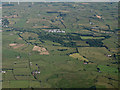
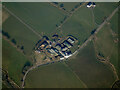
Rigfoot Farm from the air
Caldwell golf club and McLaren's Nursery are also visible.
Image: © Thomas Nugent
Taken: 19 Jul 2015
0.05 miles
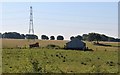
4
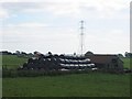
Rigfoot
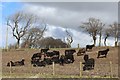
Round bale silage store. Silage fermenting in black polythene bags. Note the crow scarecrow on top. An attempt to keep away birds that may puncture the bags, although we used to have problems with fox cubs playing on them.
Image: © Richard Webb
Taken: 24 Jul 2005
0.17 miles
5

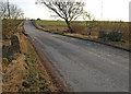
B776 to Howwood
Road from Uplawmoor to Howwood. 31st July 2009 4.50p.m.
Image: © Gordon Dowie
Taken: 31 Jul 2009
0.17 miles
6
Rigfoor Farm from the air
On the B776 Bowfield Road between Howwood and Uplawmoor.
Image: © Thomas Nugent
Taken: 27 Mar 2022
0.21 miles