IMAGES TAKEN NEAR TO
Munley Way, GLASGOW, G78 3RE
Introduction
This page details the photographs taken nearby to Munley Way, G78 3RE by members of the Geograph project.
The Geograph project started in 2005 with the aim of publishing, organising and preserving representative images for every square kilometre of Great Britain, Ireland and the Isle of Man.

There are currently over 7.5m images from over14,400 individuals and you can help contribute to the project by visiting https://www.geograph.org.uk
Image Map
Images are licensed for reuse under creativecommons.org/licenses/by-sa/2.0
Notes
- Clicking on the map will re-center to the selected point.
- The higher the marker number, the further away the image location is from the centre of the postcode.
Image Listing (8 Images Found)
Images are licensed for reuse under creativecommons.org/licenses/by-sa/2.0
Image
Details
Distance
1
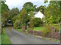
Leafy corner
On the eastern outskirts of Neilston.
Image: © James Allan
Taken: 19 Sep 2009
0.07 miles
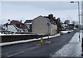
2
Entry to Neilston
Approaching from the east.
Image: © James Allan
Taken: 19 Sep 2009
0.07 miles
3
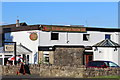
The Travellers Rest, Neilston Road, Neilston
Image: © Leslie Barrie
Taken: 9 Jul 2014
0.19 miles
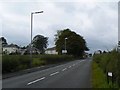
4
Neilston Road
Viewed from the junction with High Street and Main Street.
Image: © Thomas Nugent
Taken: 30 Dec 2009
0.21 miles
5
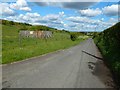
Fereneze Road at Killoch
The road leaves this OS grid square about 50 metres ahead.
Visible directly behind the small enclosure to the left of the road are some trees: they stand alongside a disused lade whose channel leads to a reservoir at Image The reservoir served Gateside Cotton Mill, which is now gone, replaced by housing.
The course of the old lade cannot be discerned from this part of the road, but it is marked on the 1:25000 map. The course of the lade can, though, be picked out from elsewhere on the road, further to the north-east: Image
Image: © Lairich Rig
Taken: 23 May 2016
0.23 miles
6
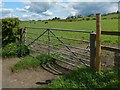
Field gate
The gate is on Fereneze Road, and opposite Killoch. The houses in the background are on Neilston Road, at Nether Kirkton.
Image: © Lairich Rig
Taken: 23 May 2016
0.24 miles
7
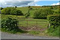
Course of an old lade
The view is from Fereneze Road. The fence leading directly away from the left-hand side of the field gate is marked as a boundary on the 1:25000 map.
Note the presence of lines of trees, parallel to the road, on either side of that fence. The lines are staggered: the trees to the right of the fence are nearer than those to the left.
Those trees stand alongside a watercourse that is marked on the 1:25000 map. It is an old lade, and, as the map shows, it makes an abrupt change of direction to follow a short section of the fence before resuming its north-easterly course.
As is pointed out at Image, the lade leads to an old reservoir at Image, which once served Gateside Cotton Mill. The mill itself is now gone, replaced by housing.
Image: © Lairich Rig
Taken: 23 May 2016
0.24 miles
8
Killoch Farm
Sits at the foot of Killoch Glen, north of Neilston.
Image: © Stephen Sweeney
Taken: 6 Jan 2010
0.25 miles