IMAGES TAKEN NEAR TO
Robertson Crescent, GLASGOW, G78 3HD
Introduction
This page details the photographs taken nearby to Robertson Crescent, G78 3HD by members of the Geograph project.
The Geograph project started in 2005 with the aim of publishing, organising and preserving representative images for every square kilometre of Great Britain, Ireland and the Isle of Man.

There are currently over 7.5m images from over14,400 individuals and you can help contribute to the project by visiting https://www.geograph.org.uk
Image Map (Loading...)


Getting Data...Please wait
Leaflet Map data © OpenStreetMap
Images are licensed for reuse under creativecommons.org/licenses/by-sa/2.0
Notes
- Clicking on the map will re-center to the selected point.
- The higher the marker number, the further away the image location is from the centre of the postcode.
Image Listing (83 Images Found)
Images are licensed for reuse under creativecommons.org/licenses/by-sa/2.0
Image
Details
Distance
1
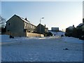
Low Broadlie Road
Residential street in Neilston, East Renfrewshire.
Image: © Stephen Sweeney
Taken: 6 Jan 2010
0.05 miles
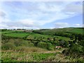
2
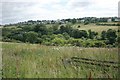
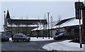
Northwest side of Neilston
Looking from the junction of Ferenze Road and Station Brae towards Neilston. The distinctive square shape of Neilston Parish Church [http://www.geograph.org.uk/photo/5311576] with its tower can be seen on the horizon in the centre.
Image: © Richard Sutcliffe
Taken: 14 Jul 2017
0.05 miles
4
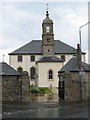
Neilston Parish Church
The Church of Scotland parish church in Neilston has been on this site since 1163. It was built by Sir Robert de Croc. The only remaining ancient part of the building is a Gothic window in a back wall and a burial vault. In 1796 the roof was taken off and another storey added making room for a gallery to accommodate the growing population.
The graveyard has a stone dating back to the 15th century.
Image: © John Allan
Taken: 2 Aug 2006
0.10 miles
5
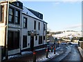
The Black Horse
Pub in Neilston. Formerly known as The Gleniffer View.
Image: © Stephen Sweeney
Taken: 6 Jan 2010
0.11 miles
6
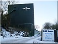
The Clyde Leather Co, Neilston
Former mill in Neilston, converted to a leather wholesalers but I don't know if it's still in use at all now.
Image: © Stephen Sweeney
Taken: 6 Jan 2010
0.11 miles
7
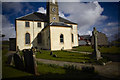
Neilston parish church
Neilston parish church, clock tower and cemetery photographed as part of the Spirit of Scotland remembrance project : http://the-remembrance-project.blogspot.co.uk/
92 photos of the church grounds taken Good Friday March 25th 2015 :https://www.flickr.com/photos/its-all-pretty-cool_dot-com/albums/72157666413542225
Neilston Village site : http://www.drookitagain.co.uk/coppermine/displayimage.php?album=1&pid=2279#top_display_media
Wiki info : https://en.wikipedia.org/wiki/Neilston
Image: © david cameron photographer
Taken: 25 Mar 2016
0.12 miles
8
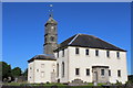
Neilston Parish Church
Category B-listed. Built c1762 incorporating part of the pre-Reformation church. Additions were made in 1798 and later.
Image: © Leslie Barrie
Taken: 9 Jul 2014
0.12 miles
9
Main Street
Broadlie Court is to the right.
Image: © Thomas Nugent
Taken: 30 Dec 2009
0.12 miles
10
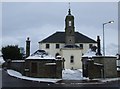
Neilston Parish Church
A church has stood on this site since 1163. Alexander Fleming (who discovered Penicillin) was once the minister here.
Image: © Thomas Nugent
Taken: 30 Dec 2009
0.12 miles