IMAGES TAKEN NEAR TO
Neilston, GLASGOW, G78 3DD
Introduction
This page details the photographs taken nearby to G78 3DD by members of the Geograph project.
The Geograph project started in 2005 with the aim of publishing, organising and preserving representative images for every square kilometre of Great Britain, Ireland and the Isle of Man.

There are currently over 7.5m images from over14,400 individuals and you can help contribute to the project by visiting https://www.geograph.org.uk
Image Map
Images are licensed for reuse under creativecommons.org/licenses/by-sa/2.0
Notes
- Clicking on the map will re-center to the selected point.
- The higher the marker number, the further away the image location is from the centre of the postcode.
Image Listing (4 Images Found)
Images are licensed for reuse under creativecommons.org/licenses/by-sa/2.0
Image
Details
Distance
1
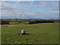
Fields next to Moyne Farm
The picture looks north over the fields on the west side of the minor road passing Moyne Farm.
Image: © Alec MacKinnon
Taken: 17 Sep 2017
0.11 miles
2
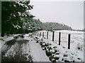
Track below Moyne Moor
The track from Lochend Hill continues past this conifer plantation which appears to be used for rearing pheasants. It eventually meets the road close to Moyne Farm.
Image: © Mark Nightingale
Taken: 4 Mar 2009
0.14 miles
3
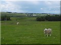
Pasture, Moyne Farm
Another shower dodged.
Image: © Richard Webb
Taken: 25 Jun 2016
0.16 miles
4
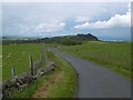
Moyne Moor road
The higher parts of the road from Dunlop to Neilston via Moyne Moor.
Image: © Richard Webb
Taken: 25 Jun 2016
0.19 miles