IMAGES TAKEN NEAR TO
Muirhead Road, GLASGOW, G78 3BL
Introduction
This page details the photographs taken nearby to Muirhead Road, G78 3BL by members of the Geograph project.
The Geograph project started in 2005 with the aim of publishing, organising and preserving representative images for every square kilometre of Great Britain, Ireland and the Isle of Man.

There are currently over 7.5m images from over14,400 individuals and you can help contribute to the project by visiting https://www.geograph.org.uk
Image Map
Images are licensed for reuse under creativecommons.org/licenses/by-sa/2.0
Notes
- Clicking on the map will re-center to the selected point.
- The higher the marker number, the further away the image location is from the centre of the postcode.
Image Listing (16 Images Found)
Images are licensed for reuse under creativecommons.org/licenses/by-sa/2.0
Image
Details
Distance
1
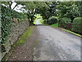
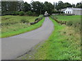
Lane at Jaapston
Looking north-westward.
Image: © Peter Wood
Taken: 14 Sep 2016
0.03 miles
2
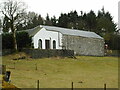
Jaapston Farm
The western side of the farm buildings.
Image: © Richard Sutcliffe
Taken: 23 Feb 2023
0.03 miles
3
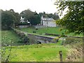
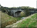
Jaapston Bridge
Road bridge across a vanished railway.
Image: © James Allan
Taken: 19 Sep 2009
0.06 miles
4
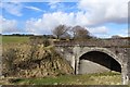
Old railway bridge
The bridge carried the minor road over the former Lanarkshire and Ayrshire Railway, which closed in 1962. Jaapston Farm is behind.
Image: © Richard Sutcliffe
Taken: 23 Feb 2023
0.06 miles
5
Old railway bridge
The bridge carries a minor road over the former Lanarkshire and Ayrshire Railway. This part of the line closed in 1962.
Image: © Richard Sutcliffe
Taken: 23 Feb 2023
0.06 miles
6
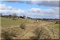
Dismantled railway near Jaapston
Neilston can be seen in the far distance
Image: © Leslie Barrie
Taken: 23 Mar 2015
0.07 miles
7
Bridge over dismantled railway at Jaapston
Image: © Leslie Barrie
Taken: 23 Mar 2015
0.07 miles
8
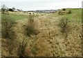
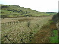
Route of former railway
Looking along the line of the former Lanarkshire and Ayrshire Railway towards Neilston in the distance. This part of the line closed in 1962.
Image: © Richard Sutcliffe
Taken: 23 Feb 2023
0.07 miles
9
Road bridge over dismantled railway near Jaapston
Looking south-eastward.
Image: © Peter Wood
Taken: 14 Sep 2016
0.07 miles
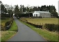
10
Route of former railway
The line of the former Lanarkshire and Ayrshire Railway is on the right. This part of the line closed in 1962. Howcraigs Hill is on the left.
Image: © Richard Sutcliffe
Taken: 23 Feb 2023
0.14 miles