IMAGES TAKEN NEAR TO
Neilston, GLASGOW, G78 3AE
Introduction
This page details the photographs taken nearby to G78 3AE by members of the Geograph project.
The Geograph project started in 2005 with the aim of publishing, organising and preserving representative images for every square kilometre of Great Britain, Ireland and the Isle of Man.

There are currently over 7.5m images from over14,400 individuals and you can help contribute to the project by visiting https://www.geograph.org.uk
Image Map
Images are licensed for reuse under creativecommons.org/licenses/by-sa/2.0
Notes
- Clicking on the map will re-center to the selected point.
- The higher the marker number, the further away the image location is from the centre of the postcode.
Image Listing (35 Images Found)
Images are licensed for reuse under creativecommons.org/licenses/by-sa/2.0
Image
Details
Distance
1
Remains of a dam on the Killoch Water
Shortly before the Killoch Water flows into the Levern Water.
Image: © G Laird
Taken: 29 Apr 2014
0.01 miles
3
Small bridge over Killoch Burn
At Gateside Road.
Image: © Stephen Sweeney
Taken: 6 Jan 2010
0.02 miles
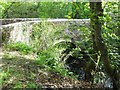
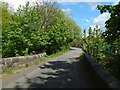
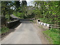
4
Killoch Bridge
The bridge crosses the Killoch Water.
Image: © Richard Sutcliffe
Taken: 14 Jul 2017
0.02 miles
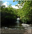
5
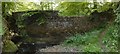
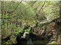
Breached weir in Killoch Glen
Taking the map at face value, this picture was taken when standing in the middle of the water just upstream of the weir. The old weir itself is breached, as shown here, and the water level above it was, after a long period of dry weather, very low: the picture was taken from an expanse of pebbles (a former mill dam); the Killoch Water was no more than a gentle burn flowing around its western margin. See also Image, a view in the opposite direction from roughly the same spot.
According to http://www.wosas.net/wosas_site.php?id=7559 (at WoSAS), the mill dam served "a small bleachfield at Low Auchentiber"; Low Auchentiber itself was at about Image
The weir and mill dam on the Killoch Water had not yet been formed when the first-edition OS map was surveyed in 1858; those features make their first appearance on the second-edition map (a revision based on surveying work carried out in 1895).
For views of the breach from the other side (and from higher up), see Image and Image
Image: © Lairich Rig
Taken: 23 May 2016
0.02 miles
6
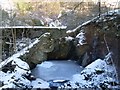
Frozen pool of water on Killoch Burn
After several weeks of icy conditions.
Image: © Stephen Sweeney
Taken: 6 Jan 2010
0.02 miles
7
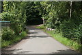
Bridge over the Killoch Water
Fereneze Road crosses the Killoch Water by means of this bridge, which is shown from the other side in Image and Image
In the present view, the buildings on the other side are part of a sewage works: Image / Image / Image
Image: © Lairich Rig
Taken: 23 May 2016
0.02 miles
8
Killoch Bridge
Carries Fereneze Road across Killoch Water.
Image: © G Laird
Taken: 29 Apr 2014
0.03 miles
9
The Killoch Water flowing into former mill dam
The pebbly area in the foreground was formerly a mill dam. The Killoch Water is shown flowing into it at the northern end, but the water level is very low after a long period of dry weather.
A view in the opposite direction shows the ruined weir of the mill dam at the other end: Image See that item for further information.
Image: © Lairich Rig
Taken: 23 May 2016
0.05 miles