IMAGES TAKEN NEAR TO
Basalt Way, G78 2FU
Introduction
This page details the photographs taken nearby to Basalt Way, G78 2FU by members of the Geograph project.
The Geograph project started in 2005 with the aim of publishing, organising and preserving representative images for every square kilometre of Great Britain, Ireland and the Isle of Man.

There are currently over 7.5m images from over14,400 individuals and you can help contribute to the project by visiting https://www.geograph.org.uk
Image Map
Images are licensed for reuse under creativecommons.org/licenses/by-sa/2.0
Notes
- Clicking on the map will re-center to the selected point.
- The higher the marker number, the further away the image location is from the centre of the postcode.
Image Listing (25 Images Found)
Images are licensed for reuse under creativecommons.org/licenses/by-sa/2.0
Image
Details
Distance
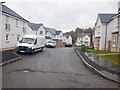
1
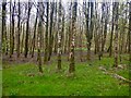
Woodland, north of Springfield Road
Almost surrounded by new houses, and building sites.
Image: © Richard Webb
Taken: 27 Apr 2021
0.08 miles
2
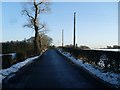
Springfield Road
In the countryside south of Barrhead.
Image: © Stephen Sweeney
Taken: 6 Jan 2010
0.08 miles
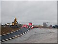
3
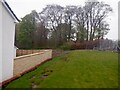
Slumped ground
Slippage above new houses. I was heading for the woods which I had hoped would get me around a road closure. Unfortunately they had used Heras to block the bridge over the Aurs Burn so I ended up losing height anyway. Good fun exploring though, even though I was annoyed.
Image: © Richard Webb
Taken: 27 Apr 2021
0.08 miles
4
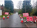
Springfield Road
Closed for a huge building site to the south. Closing the bridge over the deep Aurs Glen to pedestrian traffic was just mean.
Image: © Richard Webb
Taken: 27 Apr 2021
0.11 miles
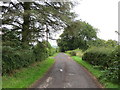
5

Road to Netherton
Leads off Springhill Road.
Image: © Stephen Sweeney
Taken: 6 Jan 2010
0.13 miles
7
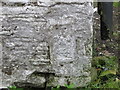
Ordnance Survey Flush Bracket G197
This heavily over-painted flush bracket can be found on the wall of a building at Netherton Farm.
For more detail see : http://www.bench-marks.org.uk/bm16865
Image: © Peter Wood
Taken: 14 Sep 2016
0.14 miles
8
Closed road
Due to house building. There was a reasonable alternative to the north but I went exploring the woodland around the Aurs Burn, north of the road which was interesting but led to some opposition from one of the builders even though it was outwith the Heras fencing and not part of the development.
Image: © Richard Webb
Taken: 27 Apr 2021
0.14 miles
9
Track to road from Netherton
Looking north-westward.
Image: © Peter Wood
Taken: 14 Sep 2016
0.14 miles
10
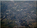
Barrhead from the air
Looking north over the town from a Prague bound flight from Glasgow.
Image: © Thomas Nugent
Taken: 27 Mar 2022
0.15 miles