IMAGES TAKEN NEAR TO
Bellfield Crescent, GLASGOW, G78 1HL
Introduction
This page details the photographs taken nearby to Bellfield Crescent, G78 1HL by members of the Geograph project.
The Geograph project started in 2005 with the aim of publishing, organising and preserving representative images for every square kilometre of Great Britain, Ireland and the Isle of Man.

There are currently over 7.5m images from over14,400 individuals and you can help contribute to the project by visiting https://www.geograph.org.uk
Image Map
Images are licensed for reuse under creativecommons.org/licenses/by-sa/2.0
Notes
- Clicking on the map will re-center to the selected point.
- The higher the marker number, the further away the image location is from the centre of the postcode.
Image Listing (104 Images Found)
Images are licensed for reuse under creativecommons.org/licenses/by-sa/2.0
Image
Details
Distance
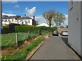
1

Cycle route in Barrhead
As Image, but from a little further on. Not far ahead, the route continues along a road once again, namely, Bellfield Crescent.
Image: © Lairich Rig
Taken: 25 Apr 2019
0.02 miles
2

Cycle route in Barrhead
The cycle path leaves Image here to pass behind what looks like sheltered housing (on the left). See Image for a view in the opposite direction from about the same spot.
For a view from further ahead (relative to the present picture), see Image
Image: © Lairich Rig
Taken: 25 Apr 2019
0.04 miles
3
Cycle route in Barrhead
The view is from the same place as in Image, but is in the opposite direction. The route turns right here, passing some sheltered housing, before meeting up with Paisley Road. It does not continues along that busy road, though, but instead turns off at Quarry Road to follow Fern Drive.
Image: © Lairich Rig
Taken: 25 Apr 2019
0.05 miles
4

Bus stop and shelter on Paisley Road (B771), Barrhead
Image: © JThomas
Taken: 24 May 2021
0.07 miles

6
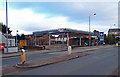
Disused Petrol Station
B771, Paisley Road, Dunterlie area of Barrhead.
Image: © wfmillar
Taken: 15 Feb 2012
0.10 miles
7
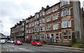
Tenement on Paisley Road
Actually two tenements, the nearer being more plain, but with front gardens and no shops on the ground floor.
Image: © Thomas Nugent
Taken: 31 Mar 2018
0.11 miles
8
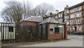
Old buildings on Paisley Road
Near Barrhead railway station, possibly originally railway related.
Image: © Thomas Nugent
Taken: 31 Mar 2018
0.11 miles
9

Paisley Road
It is seen here from the junction with Quarry Road; the building directly ahead is shown and described in other contributors' earlier pictures: Image / Image
Image: © Lairich Rig
Taken: 25 Apr 2019
0.11 miles
10
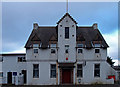
United Services Club Building
Paisley Road, Dunterlie
Image: © wfmillar
Taken: 15 Feb 2012
0.12 miles