IMAGES TAKEN NEAR TO
Hillside Grove, GLASGOW, G78 1HB
Introduction
This page details the photographs taken nearby to Hillside Grove, G78 1HB by members of the Geograph project.
The Geograph project started in 2005 with the aim of publishing, organising and preserving representative images for every square kilometre of Great Britain, Ireland and the Isle of Man.

There are currently over 7.5m images from over14,400 individuals and you can help contribute to the project by visiting https://www.geograph.org.uk
Image Map
Images are licensed for reuse under creativecommons.org/licenses/by-sa/2.0
Notes
- Clicking on the map will re-center to the selected point.
- The higher the marker number, the further away the image location is from the centre of the postcode.
Image Listing (30 Images Found)
Images are licensed for reuse under creativecommons.org/licenses/by-sa/2.0
Image
Details
Distance
1
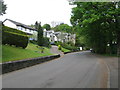
Gateside Road, Barrhead
Attractive road in the outskirts of Barrhead.
Image: © G Laird
Taken: 29 Apr 2014
0.07 miles
2
Hillside Road, Barrhead
The view is to the left from the foot of a Image
Image: © Lairich Rig
Taken: 2 May 2016
0.10 miles
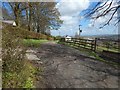
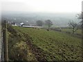
3
Railway line and Chappell Wester
From Gateside Road.
Image: © Stephen Sweeney
Taken: 6 Jan 2010
0.13 miles
4
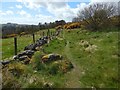
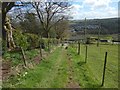
Path beside a dry-stone wall
The subject is as in Image, but the view is in the opposite direction and from a point 60 metres further to the south-west along the path.
The partly-wooded hill on the skyline at the left is Neilston Pad (see Image for comments on its name).
Image: © Lairich Rig
Taken: 2 May 2016
0.14 miles
5
Descending path
The path ends 40 metres ahead, near Image, with some wooden steps. For a view back up the path from there, see Image
From that point, Image, leads away to the left (ENE).
Image: © Lairich Rig
Taken: 2 May 2016
0.15 miles
6
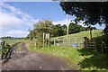
Fairy knees
Road at Woodneuk on the Fereneze Braes. (I'm sure Fereneze was in that 1960 Real Madrid team).
Image: © Richard Webb
Taken: 9 Sep 2017
0.16 miles
7
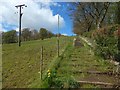
Path beside a dry-stone wall
At the time of writing, the path is not marked on the map, but the adjacent dry-stone wall and fence are marked as a boundary on the 1:25000 map.
See Image for a view in the opposite direction from 60 metres to the south-west on the same path.
Image: © Lairich Rig
Taken: 2 May 2016
0.16 miles
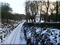
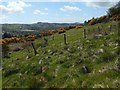
8
Ascending path
The view of from the foot of the path that is shown, from higher up, and viewed in the opposite direction, in Image
Image: © Lairich Rig
Taken: 2 May 2016
0.16 miles
9
Farmland north of Woodneuk Farm
The farm itself can be seen to the left of the image.
Image: © Stephen Sweeney
Taken: 3 Mar 2011
0.17 miles
10
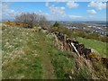
The Fereneze Hills
The fence is encountered after walking a little further along the old path shown in Image
The skyline hill a little left of centre is Neilston Pad (Image) in Image ("so called from its resemblance to a pillion" – OS Name Books).
The Old Statistical Account (1792) had earlier commented on the name: "The craig of Nielston, in the south part of the parish is the highest in the district, and the only hill which stands by itself, not forming a ridge or tract of the country. It is vulgarly called the Pad, from having in its appearance the form of a pillion. It is 820 feet about the flood mark, and yet is all green, and arable to the very top, though now only used for pasture."
The book "Paisley Poets" (1890) elaborates: "The Pad is a local vulgar name given to the Crag of Neilson, from its having the form of a pillion or cushion for a woman to ride behind another person on horseback."
The hill on the right, beside the point where the foreground hillside hides the distant skyline from view, is Knockenae Plantation (Image) in Image
Some distant wind turbines are visible. Those almost behind the Knockenae Plantation are centred on c.Image Others, near the far left edge of the picture, are centred on c.Image
- - • - -
The name Fereneze itself is of interest, and local historians have given several different explanations for it (the name struck me as having an odd feel, which is what prompted me to look further into its origin). For example, Robert Brown, in the first volume of his "History of Paisley" (1886), had explained it as "fir ness", that is, "the promontory or upland of firs". David Pride, author of "A History of the Parish of Neilston" (1910), understood it to be derived from Gaelic words meaning "alder meadow" or "alder marsh".
More recently, G W S Barrow, in his book "The Kingdom of the Scots" (2003), pointed out that "Fereneze" is a "ghost-name", one that had "apparently arisen through the misinterpretation of a term occurring in documents of the twelfth and thirteenth centuries".
Some very early forms of the name can be found in the Paisley charters, which were written in Latin. Transcriptions of them were published in the "Registrum Monasterii de Passelet" (Maitland Club Edition, Edinburgh, 1832). The earliest forms of the name, as found in those charters, are as follows, with their respective dates (and page numbers, which refer to the Maitland Club Edition):
• "Forineisun" (1165–73), on page 6,
• "Ferineisun" (1177–99), on page 12, and
• "Forineisim" (1208–18), occurring twice on page 17.
In each of those occurrences, the subject matter is the same: the skins of hinds taken either in ("in"), within ("infra"), or outside ("extra") of Forineisun.
Barrow explains that the word that our printed edition transcribes as "Forineisun" should correctly have been read "Formeisun", derived from the Old French "fermeyson", a word which passed into English as "fermison", and which meant "the close season for stags and time for hunting hinds". The charters would then be referring to the skins of hinds that were taken either in or out of that season.
This French-derived legal term was later misunderstood to be a place-name, and came to be associated with the particular area that still bears it. Barrow explains that the misunderstanding of the word developed early: a document of 1504 already refers to a "village of Ferrenes" in the parish of Paisley.
See Barrow's book, already cited, for further details. The relevant passage is in chapter 15, "The Earliest Stewarts and their Lands".
Image: © Lairich Rig
Taken: 2 May 2016
0.17 miles