IMAGES TAKEN NEAR TO
Gateside Road, GLASGOW, G78 1EW
Introduction
This page details the photographs taken nearby to Gateside Road, G78 1EW by members of the Geograph project.
The Geograph project started in 2005 with the aim of publishing, organising and preserving representative images for every square kilometre of Great Britain, Ireland and the Isle of Man.

There are currently over 7.5m images from over14,400 individuals and you can help contribute to the project by visiting https://www.geograph.org.uk
Image Map
Images are licensed for reuse under creativecommons.org/licenses/by-sa/2.0
Notes
- Clicking on the map will re-center to the selected point.
- The higher the marker number, the further away the image location is from the centre of the postcode.
Image Listing (117 Images Found)
Images are licensed for reuse under creativecommons.org/licenses/by-sa/2.0
Image
Details
Distance
1
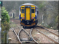
Points south of Barrhead railway station
Scotrail Class 156 train number 156 462 is crossing over from the south bound track to the single track stretch of the line which runs from here to Lugton (approx 7 miles).
See also Image
Image: © Thomas Nugent
Taken: 31 Mar 2018
0.03 miles
2
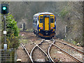
Points south of Barrhead railway station
Scotrail Class 156 train number 156 462 has just crossed over from the south bound track to the single track stretch of the line which runs from here to Lugton (approx 7 miles).
See also Image
Image: © Thomas Nugent
Taken: 31 Mar 2018
0.03 miles
3
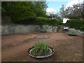
Memorial Garden for James Maxton MP
This memorial garden, called Maxton Gardens, is just off Gateside Road.
As the information panel on the right explains, these are memorial gardens for James Maxton (1885–1946), MP for Bridgeton from 1922–46; the gardens were gifted by his wife. The panel provides further biographical details of the MP. A stone with a plaque can be seen in the wall on the left: see Image for a close view of it.
Some additional information not provided on the panel: James Maxton was survived by his second wife, Madeline (née Madeline Glasier), and by his son from his previous marriage. It was therefore Madeline Maxton who was responsible for gifting these gardens to the people of Barrhead.
Image: © Lairich Rig
Taken: 23 May 2016
0.05 miles
4
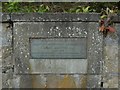
Plaque in Maxton Gardens
For context, see Image, where this stone, with its plaque, is visible on the left. The text is legible, but is given here to make it easier to find (the first quotation is slight reshaping of 2 Timothy 4:7, and the second is from Shakespeare's "Antony and Cleopatra"):
Burgh of Barrhead
Maxton Memorial Committee
James Maxton M.A.
1885–1946
Member of Parliament for Bridgeton 1922–1946
"He fought a good fight, he kept the faith"
"A rarer spirit never did steer humanity"
Image: © Lairich Rig
Taken: 23 May 2016
0.05 miles
5
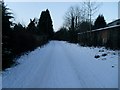
Chappell Street, Barrhead
Completely snowed over.
Image: © Stephen Sweeney
Taken: 6 Jan 2010
0.05 miles
6
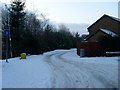
Levern Gardens, Barrhead
Tucked between Chappell Street and the Levern Water.
Image: © Stephen Sweeney
Taken: 6 Jan 2010
0.07 miles
7
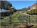
Joining the Fereneze Braes Path Network at Barrhead
The picture was taken in Barrhead, and the view is from Graham Street, at its junction with Laurel Way. The nearby signpost points to "Barrhead Station" and "Killoch Glen". Further ahead is an information panel, which is titled "Fereneze Braes Path Network", with pictures and further information about the area.
For a view from a little further back, see another contributor's earlier image: Image
For a view back across this part of the path from not far ahead, see Image, which also clarifies where the present picture was taken from.
There has been a path at this spot for over a century, and, a century ago, it led uphill (WNW) to a pavilion that stood at Image, in what is now the golf course of Fereneze Golf Club. From that pavilion, another path led SSW, back downhill. Some traces of that other path can still be discerned on the golf course (Image) and outside it (Image and Image).
Image: © Lairich Rig
Taken: 2 May 2016
0.09 miles
8
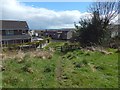
Leaving the Fereneze Braes Path Network at Barrhead
The area is shown, from the other side, in Image For example, the back of an information panel that is shown in that picture can be seen in the present view, just beyond the nearer of the two wooden fences. Not far beyond that, at the second fence, the path ends at Graham Street in Barrhead.
As noted at the link just given, there has been a path here for over a century.
Image: © Lairich Rig
Taken: 2 May 2016
0.09 miles
9
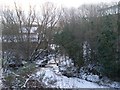
Levern Water
Passing Chappell Street in Barrhead.
Image: © Stephen Sweeney
Taken: 6 Jan 2010
0.09 miles
10
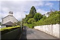
Hillside Road
Quite a steep slope amongst houses with a southward view.
Image: © Richard Webb
Taken: 9 Sep 2017
0.10 miles