IMAGES TAKEN NEAR TO
Eagle Avenue, GLASGOW, G77 6WN
Introduction
This page details the photographs taken nearby to Eagle Avenue, G77 6WN by members of the Geograph project.
The Geograph project started in 2005 with the aim of publishing, organising and preserving representative images for every square kilometre of Great Britain, Ireland and the Isle of Man.

There are currently over 7.5m images from over14,400 individuals and you can help contribute to the project by visiting https://www.geograph.org.uk
Image Map
Images are licensed for reuse under creativecommons.org/licenses/by-sa/2.0
Notes
- Clicking on the map will re-center to the selected point.
- The higher the marker number, the further away the image location is from the centre of the postcode.
Image Listing (15 Images Found)
Images are licensed for reuse under creativecommons.org/licenses/by-sa/2.0
Image
Details
Distance

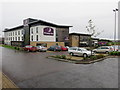
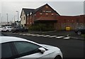
3
Miller and Carter Steakhouse
Previously known as The Osprey.
Image: © Richard Sutcliffe
Taken: 8 Dec 2017
0.16 miles
5
Miller and Carter Steakhouse
Previously known as The Osprey.
Image: © Richard Sutcliffe
Taken: 8 Dec 2017
0.16 miles
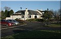
7
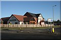
The Capelrig, Newton Mearns
A 'Hungry Horse' pub and restaurant.
Not my local.
Image: © Richard Sutcliffe
Taken: 8 Dec 2017
0.20 miles
8
The Capelrig, Newton Mearns
A 'Hungry Horse' pub and restaurant.
Image: © Richard Sutcliffe
Taken: 8 Dec 2017
0.20 miles
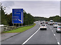
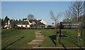
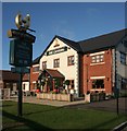
9
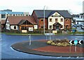
The Capelrig
Public house beside a roundabout on the B7087. Capelrig is the name of the local estate, which dates back to the 12th century.
Image: © Richard Sutcliffe
Taken: 15 Feb 2023
0.21 miles