IMAGES TAKEN NEAR TO
Langlee Road, GLASGOW, G77 6SA
Introduction
This page details the photographs taken nearby to Langlee Road, G77 6SA by members of the Geograph project.
The Geograph project started in 2005 with the aim of publishing, organising and preserving representative images for every square kilometre of Great Britain, Ireland and the Isle of Man.

There are currently over 7.5m images from over14,400 individuals and you can help contribute to the project by visiting https://www.geograph.org.uk
Image Map
Images are licensed for reuse under creativecommons.org/licenses/by-sa/2.0
Notes
- Clicking on the map will re-center to the selected point.
- The higher the marker number, the further away the image location is from the centre of the postcode.
Image Listing (7 Images Found)
Images are licensed for reuse under creativecommons.org/licenses/by-sa/2.0
Image
Details
Distance
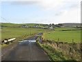
1
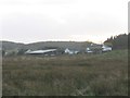
Langlee Farm
Farm south of the East Renfrewshire Golf Club.
Image: © G Laird
Taken: 14 Nov 2013
0.02 miles
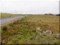
3
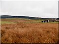
Rashy ground, Langlee
Not surprisingly forestry has a foothold in these hills.
Image: © Richard Webb
Taken: 27 Apr 2021
0.08 miles
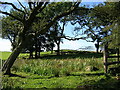
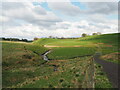
5
Road to South Moorhouse Farm and Water Works
Image: © Richard Webb
Taken: 27 Apr 2021
0.16 miles
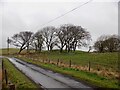
6
Road to South Moorhouse Farm and Water Works
At the point where the road crosses a small burn.
Image: © G Laird
Taken: 14 Nov 2013
0.22 miles
7
Earn Water near Brownside
The burn called Earn Water is seen here from the track across the country between Brownside and Langlee, just after its merger with the Blackloch Burn.
Image: © Alec MacKinnon
Taken: 7 May 2023
0.22 miles