IMAGES TAKEN NEAR TO
Capelrig Drive, GLASGOW, G77 6NW
Introduction
This page details the photographs taken nearby to Capelrig Drive, G77 6NW by members of the Geograph project.
The Geograph project started in 2005 with the aim of publishing, organising and preserving representative images for every square kilometre of Great Britain, Ireland and the Isle of Man.

There are currently over 7.5m images from over14,400 individuals and you can help contribute to the project by visiting https://www.geograph.org.uk
Image Map
Images are licensed for reuse under creativecommons.org/licenses/by-sa/2.0
Notes
- Clicking on the map will re-center to the selected point.
- The higher the marker number, the further away the image location is from the centre of the postcode.
Image Listing (10 Images Found)
Images are licensed for reuse under creativecommons.org/licenses/by-sa/2.0
Image
Details
Distance
1
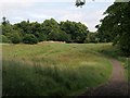
Meadow in Rouken Glen Park
This attractive meadow lies at the southern edge of Rouken Glen Park. The Auldhouse Burn and its waterfalls lie in the trees at upper left.
Image: © Alec MacKinnon
Taken: 15 Jul 2013
0.20 miles
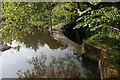
2
Weir on the Auldhouse Burn in Rouken Glen Park
Only just up river from the main waterfall. From the bridge in the photograph you can observe the weir to the left and the waterfall to the right.
Image: © G Laird
Taken: 21 Dec 2012
0.21 miles
3
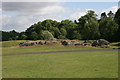
Picnic Rocks, Rouken Glen Park
An outcrop of Giffnock Sandstone in Rouken Glen Park, known as the Picnic Rocks.
Image: © Richard Sutcliffe
Taken: 2 Jul 2010
0.21 miles
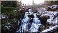
4
Weir on the Auldhouse Burn
The Auldhouse Burn tumbles over this weir before forming Rouken Glen Park's pretty waterfalls (e.g. Image). The tradition of throwing coins into wishing wells seems to have been extended to all other sorts of water attractions and one sees many coins lying on the boulders below the weir. It's amusing to compare the volume of water in this picture from the middle of July with the December view of Image
Image: © Alec MacKinnon
Taken: 15 Jul 2013
0.22 miles
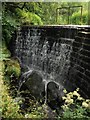
5
Weir on the Auldhouse Burn
Seen from the side of the weir. Very little water was flowing when this photograph was taken.
Image: © Richard Sutcliffe
Taken: 4 Jun 2010
0.22 miles
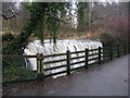
7
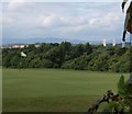
Hole on Deaconsbank Golf Course
Deaconsbank Golf Course adjoins Rouken Glen Park. From a pth inside the Park this photo peers through a gap in the hedge onto one of the greens. Descriptions of the course usually note its elevated location and the resulting views, also evident in this picture.
Image: © Alec MacKinnon
Taken: 15 Jul 2013
0.23 miles
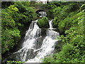
9
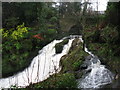
Waterfall on the Auldhouse Burn in Rouken Glen Park
The bridge in the background separates the weir and the waterfall.
Image: © G Laird
Taken: 21 Dec 2012
0.24 miles
10
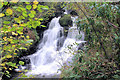
Waterfall Rouken Glen Park.
The waterfall at the park. Although situated in East Renfrewshire this park was donated for the people of Glasgow....
Image: © John McLeish
Taken: 3 Apr 2006
0.25 miles