IMAGES TAKEN NEAR TO
Broom Road East, GLASGOW, G77 5RL
Introduction
This page details the photographs taken nearby to Broom Road East, G77 5RL by members of the Geograph project.
The Geograph project started in 2005 with the aim of publishing, organising and preserving representative images for every square kilometre of Great Britain, Ireland and the Isle of Man.

There are currently over 7.5m images from over14,400 individuals and you can help contribute to the project by visiting https://www.geograph.org.uk
Image Map
Images are licensed for reuse under creativecommons.org/licenses/by-sa/2.0
Notes
- Clicking on the map will re-center to the selected point.
- The higher the marker number, the further away the image location is from the centre of the postcode.
Image Listing (16 Images Found)
Images are licensed for reuse under creativecommons.org/licenses/by-sa/2.0
Image
Details
Distance
1

Mearns Castle Trig Point
The trig point is situated beside Mearns Castle High School and from here there is a good view over Newton Mearns towards the Campsie Fells in the distance.
Image: © G Laird
Taken: 1 Jan 2013
0.08 miles
3

Farm track
We look along the same track seen in Image
Image: © Alec MacKinnon
Taken: 15 Apr 2014
0.17 miles
4

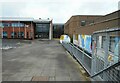
The rear of Mearns Castle High School
Seen from beside Mearns Castle.
Image: © Richard Sutcliffe
Taken: 15 Feb 2023
0.19 miles
5
Mearns Castle High School
This image was taken to replicate the first image for this square Image taken and submitted in 2005.
Image: © Richard Sutcliffe
Taken: 15 Feb 2023
0.20 miles
6
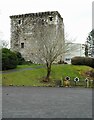
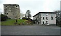
Mearns Castle
A Category A listed http://portal.historicenvironment.scot/designation/LB18536 15th century tower house. It was converted into a church in the late 1960s before a new modern church (on the right) was built attached to the tower in 1971.
See Mearns History Group https://mearnshistory.org.uk/index.php/history/castles/mearns-castle for more information.
Image: © Richard Sutcliffe
Taken: 15 Feb 2023
0.20 miles
7

Mearns Castle High School
The school entrance seen from the pavement just outside the grounds.
Image: © Richard Sutcliffe
Taken: 15 Feb 2023
0.20 miles
8
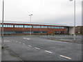
Mearns Castle High School
Mearns Castle High School is a secondary school situated on Waterfoot Road in Newton Mearns.
Image: © G Laird
Taken: 1 Jan 2013
0.20 miles
9
Ancient and modern
The ancient (15th century) Category A listed http://portal.historicenvironment.scot/designation/LB18536 tower house (Mearns Castle), with the 1971 Maxwell Mearns Castle Parish Church behind and similarly modern accommodation on the right.
See Mearns History Group https://mearnshistory.org.uk/index.php/history/castles/mearns-castle for more information.
Image: © Richard Sutcliffe
Taken: 15 Feb 2023
0.21 miles
10
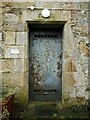
Metal door to the castle
A steel door with grills top and bottom into the Category A listed http://portal.historicenvironment.scot/designation/LB18536 Mearns Castle. The castle is not open to the public. The small, faded plaque to the left of the door reads:
COUNTY COUNCIL OF THE COUNTY OF RENFREWSHIRE
This historic building has been
restored with the aid of
the Renfrewshire Heritage Committee
BUILDINGS OF ARCHITECTURAL & HISTORIC INTEREST
The County Council has not existed since local government reorganisation in 1975. Sadly the castle looks to be in need of attention again, with much pointing required and it is home to numbers of jackdaws which appear to be gaining access through the arrow slits. In fact the castle has been on the Buildings at Risk Register since 2008 https://www.buildingsatrisk.org.uk/search/town/newton%20mearns/order/1//event_id/908609/building_name/mearns-castle-broom-road-newton-mearns.
Image: © Richard Sutcliffe
Taken: 15 Feb 2023
0.21 miles