IMAGES TAKEN NEAR TO
Burnhouse Brae, GLASGOW, G77 5RB
Introduction
This page details the photographs taken nearby to Burnhouse Brae, G77 5RB by members of the Geograph project.
The Geograph project started in 2005 with the aim of publishing, organising and preserving representative images for every square kilometre of Great Britain, Ireland and the Isle of Man.

There are currently over 7.5m images from over14,400 individuals and you can help contribute to the project by visiting https://www.geograph.org.uk
Image Map (Loading...)


Getting Data...Please wait
Leaflet Map data © OpenStreetMap
Images are licensed for reuse under creativecommons.org/licenses/by-sa/2.0
Notes
- Clicking on the map will re-center to the selected point.
- The higher the marker number, the further away the image location is from the centre of the postcode.
Image Listing (23 Images Found)
Images are licensed for reuse under creativecommons.org/licenses/by-sa/2.0
Image
Details
Distance
1
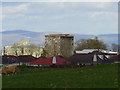
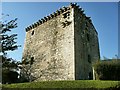
Mearns Castle & Maxwell Mearns Church
The Maxwells of Caerlaverock tower rises to four storeys and it was partially once enclosed by a wall, with a moat. These details were spelt out in a document by King James II in 1449, when the monarch granted a licence to erect a castle with these specific requirements: “to build a castle or fortalice in the barony of Mearns in Renfrewshire, to surround and fortify it with walls and ditches to strengthen it by iron gates and to erect on top of it all warlike apparatus necessary for its defense.” The castle has a vaulted basement and a vaulted first floor hall.
Image: © Alan Murray Walsh
Taken: 19 Apr 2007
0.04 miles
2
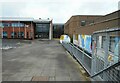
Mearns Castle High School
The entrance to the school taken from the main road. You can just about read the school name above the door.
Image: © G McK
Taken: 31 Dec 2005
0.06 miles
3
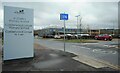
School entrance
St Clare's Primary School, Calderwood Lodge Primary School and Calderwood Lodge Nursery.
Image: © Richard Sutcliffe
Taken: 15 Feb 2023
0.08 miles
4
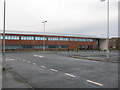
Mearns Castle High School
Mearns Castle High School is a secondary school situated on Waterfoot Road in Newton Mearns.
Image: © G Laird
Taken: 1 Jan 2013
0.08 miles
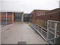
5

Mearns Castle High School
The school entrance seen from the pavement just outside the grounds.
Image: © Richard Sutcliffe
Taken: 15 Feb 2023
0.09 miles
7
Mearns Castle High School
This image was taken to replicate the first image for this square Image taken and submitted in 2005.
Image: © Richard Sutcliffe
Taken: 15 Feb 2023
0.09 miles
8
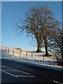
Old & New Broom Road East
The depression on the right of the small banking & left of the trees is the route of the old Broom Road East before the new Broom Road East (foreground) was built in 1983. A light pattern can be seen from the aerial image of this position, leading through the field it meets up with a tarmac section of the old road that swings north before meeting up with the new road.
Image: © Alan Murray Walsh
Taken: 8 Dec 2010
0.09 miles
9

The rear of Mearns Castle High School
Seen from beside Mearns Castle.
Image: © Richard Sutcliffe
Taken: 15 Feb 2023
0.11 miles
10
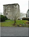
Mearns Castle
A Category A listed http://portal.historicenvironment.scot/designation/LB18536 15th century tower house. It was converted into a church in the late 1960s before a new modern church (on the right) was built attached to the tower in 1971.
See Mearns History Group https://mearnshistory.org.uk/index.php/history/castles/mearns-castle for more information.
Image: © Richard Sutcliffe
Taken: 15 Feb 2023
0.11 miles