IMAGES TAKEN NEAR TO
Humbie Lawns, GLASGOW, G77 5EA
Introduction
This page details the photographs taken nearby to Humbie Lawns, G77 5EA by members of the Geograph project.
The Geograph project started in 2005 with the aim of publishing, organising and preserving representative images for every square kilometre of Great Britain, Ireland and the Isle of Man.

There are currently over 7.5m images from over14,400 individuals and you can help contribute to the project by visiting https://www.geograph.org.uk
Image Map
Images are licensed for reuse under creativecommons.org/licenses/by-sa/2.0
Notes
- Clicking on the map will re-center to the selected point.
- The higher the marker number, the further away the image location is from the centre of the postcode.
Image Listing (25 Images Found)
Images are licensed for reuse under creativecommons.org/licenses/by-sa/2.0
Image
Details
Distance
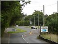
1
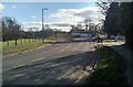
Roundabout on Mearns Road
Humbie Road is on the left. The building beyond the roundabout is a Co-op.
Image: © Richard Sutcliffe
Taken: 7 Mar 2022
0.11 miles
2
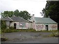
Derelict building, Mearns Road
Former licensed premises according to the estate agent's sign.
Image: © Richard Webb
Taken: 28 Aug 2016
0.12 miles
3
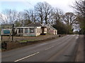
Derelict former restaurant
This building beside Mearns Road used to be a rather good Chinese restaurant that attracted business from a wide area: Newton Mearns, Clarkston, Busby etc. It has been derelict for several years.
Image: © Alec MacKinnon
Taken: 14 Apr 2017
0.12 miles
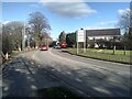
5
Mearns Road
The junction is with Humbie Road - the roundabout has been offset.
Image: © Richard Webb
Taken: 28 Aug 2016
0.13 miles
6
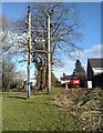
Electricity transformer
Beside Mearns Road. In the distance a workman is going up in a cherry picker, about to do some work on the adjacent house.
Image: © Richard Sutcliffe
Taken: 7 Mar 2022
0.14 miles
7
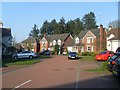
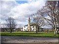
Cresswell Place, Newton Mearns
Plush residential area south of Glasgow.
Image: © Stephen Sweeney
Taken: 12 Apr 2010
0.17 miles
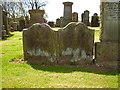
10
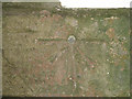
Mearns Kirk Bolt
1GL Bolt: Mearns, Church Newton Mearns Parish Church. Bolt in East face of tower ; 2.06 ft. above surface [1GL, Stranraer to Glasgow, Branch Levelling from Mark No, 219(c)]; P A BOLT BUTT S FACE MEARNS KIRK E FACE BUTT (143.4284m ODN, 0.7m AGL)
First Primary Levelling, Scotland (1844-60)
This bench mark was used during the First primary levelling, Scotland, and was levelled with a height of 469.9530 feet [143.2417 metres] above mean sea level (Liverpool datum). It was included as a side level on the Stranraer to Glasgow levelling line. The surveyor's description was Newton Mearns Parish Church. Bolt in East face of tower ; 2.06 ft. above surface.
See http://www.bench-marks.org.uk/bm28304
Image: © Ian Charters
Taken: 17 Jan 2010
0.18 miles