IMAGES TAKEN NEAR TO
Easterton Avenue, GLASGOW, G76 8JJ
Introduction
This page details the photographs taken nearby to Easterton Avenue, G76 8JJ by members of the Geograph project.
The Geograph project started in 2005 with the aim of publishing, organising and preserving representative images for every square kilometre of Great Britain, Ireland and the Isle of Man.

There are currently over 7.5m images from over14,400 individuals and you can help contribute to the project by visiting https://www.geograph.org.uk
Image Map
Images are licensed for reuse under creativecommons.org/licenses/by-sa/2.0
Notes
- Clicking on the map will re-center to the selected point.
- The higher the marker number, the further away the image location is from the centre of the postcode.
Image Listing (17 Images Found)
Images are licensed for reuse under creativecommons.org/licenses/by-sa/2.0
Image
Details
Distance
1
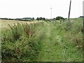
Track, Busby
Beside the railway and shown on Naturescot's core path map. I got through but it was a struggle. The East Renfrewshire council area is a bit of a black hole for core paths. This was the first of three dud paths today.
Image: © Richard Webb
Taken: 17 Aug 2022
0.10 miles
3
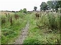
Path, Busby
There seems to be no East Renfrewshire core paths map, but the Naturescot map suggests that this is a through route to Thorntonhall. Well I did get through but I would not recommend the experience. An all too common occurrence around here and the first of three dud paths today.
Image: © Richard Webb
Taken: 17 Aug 2022
0.13 miles
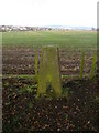
4
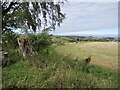
View from Busbyside triangulation pillar
Image: © Richard Webb
Taken: 17 Aug 2022
0.13 miles
5
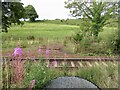
East Kilbride railway
Quite a gradient on this railway.
Image: © Richard Webb
Taken: 17 Aug 2022
0.13 miles
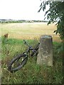
7
Busbyside Farm Trig
Busbyside Farm may have been demolished but the nearby triangulation pillar remains intact.
Image: © Mark Nightingale
Taken: 27 Jan 2010
0.14 miles
8
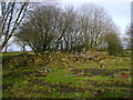
The remains of Busbyside Farm
Despite featuring on current Ordnance Survey mapping Busbyside Farm was clearly demolished a number of years ago.
Image: © Mark Nightingale
Taken: 27 Jan 2010
0.18 miles
9
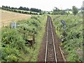
East Kilbride branch
A very rural looking line with a sharp gradient climbing from Busby.
Image: © Richard Webb
Taken: 17 Aug 2022
0.19 miles
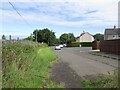
10
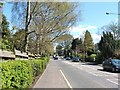
East Kilbride Road, Busby
The picture was taken from a point opposite the junction with South Road.
Image: © Lairich Rig
Taken: 29 Apr 2005
0.20 miles