IMAGES TAKEN NEAR TO
Kilpatrick Gardens, GLASGOW, G76 7RF
Introduction
This page details the photographs taken nearby to Kilpatrick Gardens, G76 7RF by members of the Geograph project.
The Geograph project started in 2005 with the aim of publishing, organising and preserving representative images for every square kilometre of Great Britain, Ireland and the Isle of Man.

There are currently over 7.5m images from over14,400 individuals and you can help contribute to the project by visiting https://www.geograph.org.uk
Image Map
Images are licensed for reuse under creativecommons.org/licenses/by-sa/2.0
Notes
- Clicking on the map will re-center to the selected point.
- The higher the marker number, the further away the image location is from the centre of the postcode.
Image Listing (9 Images Found)
Images are licensed for reuse under creativecommons.org/licenses/by-sa/2.0
Image
Details
Distance
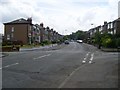
1
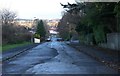
Williamwood
Residential area in East Renfrewshire. Looking to the junction of Burnside Gardens and Kilpatrick Gardens.
Image: © Stephen Sweeney
Taken: 13 Jun 2009
0.11 miles
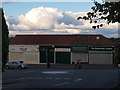
2
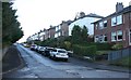
Seres Road housing
At the junction with Morven Drive.
Image: © Stephen Sweeney
Taken: 13 Jun 2009
0.14 miles
3
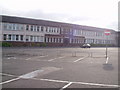
Williamwood High School
School's out for summer!
Image: © G McK
Taken: 1 Jul 2005
0.15 miles
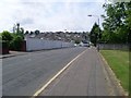
5
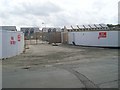
Demolition site of Williamwood High School
Completing the school closure as documented by Gordon McKinlay in 2005 and 2006.
Image: © Stephen Sweeney
Taken: 13 Jun 2009
0.21 miles
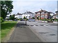
6
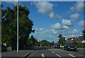
Mearns Road
This is Mearns Road as it passes through the suburb of Clarkston in Glasgow.
Image: © Malcolm Neal
Taken: 24 Sep 2022
0.22 miles