IMAGES TAKEN NEAR TO
Eaglesham, GLASGOW, G76 0QG
Introduction
This page details the photographs taken nearby to G76 0QG by members of the Geograph project.
The Geograph project started in 2005 with the aim of publishing, organising and preserving representative images for every square kilometre of Great Britain, Ireland and the Isle of Man.

There are currently over 7.5m images from over14,400 individuals and you can help contribute to the project by visiting https://www.geograph.org.uk
Image Map
Images are licensed for reuse under creativecommons.org/licenses/by-sa/2.0
Notes
- Clicking on the map will re-center to the selected point.
- The higher the marker number, the further away the image location is from the centre of the postcode.
Image Listing (10 Images Found)
Images are licensed for reuse under creativecommons.org/licenses/by-sa/2.0
Image
Details
Distance
1
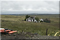
Melowther Farm
A house nestled into the hillside, no doubt in an ideal place to shelter from the weather and high winds.
Image: © Malcolm Neal
Taken: 22 Aug 2018
0.00 miles
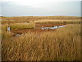
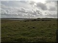
2
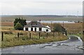
Melowther, an isolated cottage
Dunwan Dam in the background.
Image: © Alan Reid
Taken: 7 Oct 2022
0.01 miles
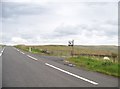
4
Eaglesham to Fenwick Cycle Route
New Eaglesham to Fenwick Cycle Route Near Melowther. The road markings narrow the previous 2-way Eaglesham Moor road to single-track with passing places and bike lanes, after the construction of the Glasgow Southern Orbital road (Eaglesham Bypass). The markings in East Ayrshire were burnt off from the Council boundary westwards for safety reasons, as many vehicles ignore them.
Image: © Iain Thompson
Taken: 19 Nov 2005
0.06 miles
5
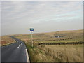
The former B764 approaching Eaglesham
The road has been down-graded to discourage through traffic
Image: © Elliott Simpson
Taken: 6 Aug 2016
0.07 miles
6
Eaglesham Moor Road near Greenfield Cottage
The picture looks west along the road over the Eaglesham Moor, from a layby close to Greenfield Cottage. On the horizon the road passes between Ballageich Hill, to the right, and Greenfield Hill with the mast.
Image: © Alec MacKinnon
Taken: 21 Feb 2021
0.09 miles
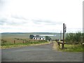
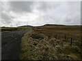
7
Fence at the Eaglesham to Kingswell road
Near Melowther.
Image: © Stephen Sweeney
Taken: 16 May 2010
0.09 miles
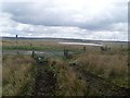
8
Looking towards Dunwan Dam
The picture looks south across the moorland from the Moor Road near Melowther, in the direction of Dunwan Dam. Part of the Whitelee windfarm lies behind.
Image: © Alec MacKinnon
Taken: 21 Feb 2021
0.12 miles
9
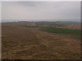
Eaglesham Moor road
From Ballageich Hill's eastern outlier the view extends east along the Eaglesham Moor road.
Image: © Alec MacKinnon
Taken: 27 Apr 2014
0.17 miles