IMAGES TAKEN NEAR TO
Eaglesham, GLASGOW, G76 0PS
Introduction
This page details the photographs taken nearby to G76 0PS by members of the Geograph project.
The Geograph project started in 2005 with the aim of publishing, organising and preserving representative images for every square kilometre of Great Britain, Ireland and the Isle of Man.

There are currently over 7.5m images from over14,400 individuals and you can help contribute to the project by visiting https://www.geograph.org.uk
Image Map
Images are licensed for reuse under creativecommons.org/licenses/by-sa/2.0
Notes
- Clicking on the map will re-center to the selected point.
- The higher the marker number, the further away the image location is from the centre of the postcode.
Image Listing (10 Images Found)
Images are licensed for reuse under creativecommons.org/licenses/by-sa/2.0
Image
Details
Distance
1
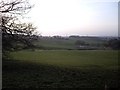
High Borland
Looking across High Borland Farm from Topfaulds Plantation. Crosslees Farm which can be seen in the distance is situated on the site of a Bronze Age cairn which survives albeit in a much reduced state.
Image: © Kenneth Mallard
Taken: 13 Apr 2010
0.03 miles
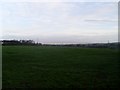
2
High Borland
Looking across High Borland Farm towards Crosslees Plantation from Topfaulds Plantation. Crosslees Farm which can be seen in the distance is situated on the site of a Bronze Age cairn which survives albeit in a much reduced state.
Image: © Kenneth Mallard
Taken: 24 Apr 2010
0.03 miles
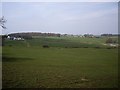
3
View north towards Glasgow
The view across farmland near Eaglesham to the city.
Image: © Stephen Sweeney
Taken: 17 Nov 2009
0.14 miles
4
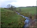
Borland Burn
Flowing towards Humbie Road, from where the image is taken.
Image: © Stephen Sweeney
Taken: 17 Nov 2009
0.20 miles
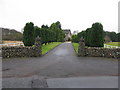
5
Castlehill Farm
On the road between Newton Mearns and Eaglesham.
Image: © Stephen Sweeney
Taken: 17 Nov 2009
0.21 miles
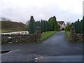
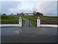
6
Entrance to Castlehill Farm
On Humbie Road near Eaglesham.
Image: © G Laird
Taken: 3 Jan 2013
0.21 miles
7
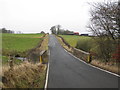
Road Bridge over the Borland Burn
On Humbie Road just outside Eaglesham.
Image: © G Laird
Taken: 3 Jan 2013
0.21 miles
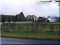
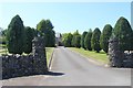
10
Gates at High Borland Farm
Just to the west of Eaglesham, on Humbie Road.
Image: © Stephen Sweeney
Taken: 17 Nov 2009
0.23 miles