IMAGES TAKEN NEAR TO
Eaglesham, GLASGOW, G76 0NU
Introduction
This page details the photographs taken nearby to G76 0NU by members of the Geograph project.
The Geograph project started in 2005 with the aim of publishing, organising and preserving representative images for every square kilometre of Great Britain, Ireland and the Isle of Man.

There are currently over 7.5m images from over14,400 individuals and you can help contribute to the project by visiting https://www.geograph.org.uk
Image Map
Images are licensed for reuse under creativecommons.org/licenses/by-sa/2.0
Notes
- Clicking on the map will re-center to the selected point.
- The higher the marker number, the further away the image location is from the centre of the postcode.
Image Listing (8 Images Found)
Images are licensed for reuse under creativecommons.org/licenses/by-sa/2.0
Image
Details
Distance
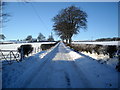
5
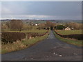
Looking down Millhall Road
The picture shows Millhall Road at its junction with Strahaven Road, the road that runs south from the village of Eaglesham. Despite the names people heading for Strathaven from Eaglesham would turn down Millhall Road.
Image: © Alec MacKinnon
Taken: 3 Mar 2020
0.13 miles
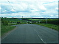
7
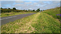
Well-cut verges on the road into Eaglesham
Image: © Gordon Brown
Taken: 30 Jun 2021
0.19 miles
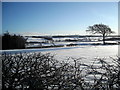
8
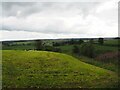
Farmland near Woodhouse
We look across the farmland toward Woodhouse from near Highhill Cottage. Just beyond the nearest field a channel carries a small burn, a tributary of the Enoch Burn.
Image: © Alec MacKinnon
Taken: 26 Jul 2023
0.25 miles